


|
|
|
|
|
|
| lrh | profile | all galleries >> Jasper ARK Pictures >> Jasper 2024 (J10) | tree view | thumbnails | slideshow |
| 2012 2013 2015 2016 2017 2018 2020 2021 2022 2024 2025 |
For 2024, our 10th time in the Jasper area (and the final time where both kids are minors), we are actually staying in the Marshall area, with the Jasper spots now about an hour away, but other spots like it pretty close-by. This was done to sort of "freshen up" the trip a bit in terms of not wanting to see the exact same spots and risk things becoming a bit "stale," but to nonetheless spend time in spots that are a lot like the Jasper spots. (Some of them, like Shine Eye, Robertson, Buffalo Point and Grinder's Ferry have in fact been visited before when we DID stay in Jasper.
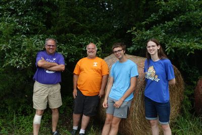
This trip will likely be remembered most for Archey Fork (link), a new spot we had found about it and became quite likely our favorite spot of all, and for KSG being there for much of it. We really liked the new Archey Fork spot, and my kids really like KSG a lot (as do I, he's a heck of a guy).
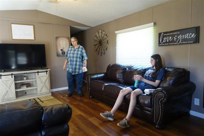
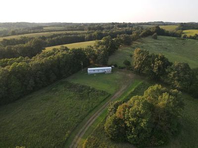
We stayed in a new-for-us rural and secluded mobile home-based cabin my wife found, it was cheaper (only about $58 per night) but in fact very good. It was very secluded and quiet, yet close to the grocery store and with excellent 5G AT&T cell phone service. It had 2 bedrooms and a pull-out couch, a full-sized kitchen, and even a washer/dryer--not bad at all for the price. The information about it follows:
| Name | Country View Get-Away |
| Address (Coordinates Are Better However) | 2226 Barren Hollow Road Marshall AR |
| GPS coordinates | 35.9531,-92.57864 N 35� 57' 11", W 92� 34' 43" |
| Google Maps Site | Link |
| AirBnB Page | Link |
Also we in fact visited the area briefly before the actual full-blown vacation, June 4-7th, as a sort of "pre-vacation mini vacation" or whatever you call it. In part, this was done because we'd observed that many times prior waterfalls were dry by the time we'd visited, but were showing as flowing in late May, so we sort of felt like getting a "peek" at what it's like in other months when it's less dry. This also allowed us to see what it would be like staying in Marshall vs Jasper, and to also prevent the fiasco from last year, when we thought he had a secluded cabin but it in fact was located immediately next door to another. (That was not a problem here at all, but we wanted to make sure ahead of time). The shots from those days will be shown as "Mini Trip" in the description.
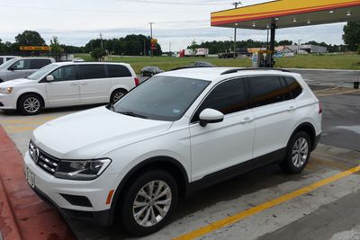
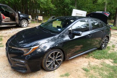
For the first time, we rented cars, and did so via Turo (link), a new site we had just learned about (which helped bypass the credit card issue). The "mini trip" we rented a small SUV, a 2019 Volkswagen Tiguan. For the "real" trip, we tried to get the VW again, but failed to, so we settled on a 2021 Toyota Corolla. It did fine, but while I like Corollas, I do wish I could've gotten the VW again, or something else similar (Ford Escape, Toyota RAV4 etc).
Spots We Visited (click here to view the detailed points of interest page).
| Name | Link | Remarks |
|---|---|---|
| Archey Fork Bluffton Preserve, PARK | 35.64558,-92.52582 | A new Gez Rogers spot for 2024 and an outstanding one. This is where you park. |
| Archey Fork Bluffton Preserve, The Spot | 35.64321,-92.52218 | The best spot, you hike about 0.2 miles then bear right down a path |
| Barkshed | 36.0192,-92.25083 | A spot from the book, not that good as I recall. |
| Bayou Bluff p 42 | 35.52389,-92.9425 | A spot near Illinois Bayou which is scenic, may have good fishing, but swimming is poor. |
| BBQ Eating Place (Slims) Near Falling Waterfalls | 35.67476,-92.95053 | An eating place my wife found near Falling Waterfalls, although also check out 'Bridget's Burgers.' |
| Bear Creek (Spider Creek) Shot | 35.922024,-92.71407 | A spot where I took a shot of Bear-Spider Creek outside of Marshall. |
| Bear Creek Hwy 65 | 35.93953,-92.7144 | A Gez Rogers spot my wife kind of likes, near the '2021 Cabins' off Hwy 65. |
| Blanchard Trailhead | 35.9591,-92.17526 | The spot we hiked in June where I hurt my leg, part of the 'Blachard series.' Other better swimming spots to check in main list. |
| Blue Hole At Victor DUD | 35.650898,-93.002806 | Wife found this spot on the fly in 2024 it was somewhat a dud. However there are Gez Rogers spots nearby, check main listing Victor 1`2 and 2`2. |
| Bojangles Prescott ARK | 33.82776,-93.39362 | A Bojangles I found out about halfway in-between in Prescott ARK right beside the Hardees. |
| Branch Hollow At Clinton (Gez Rogers) | 35.57969,-92.45555 | A tiny spot from Gez Rogers, in Clinton, checked out in June, not much. |
| Cabin 2024 | 35.9531,-92.57864 | The cabin we stayed at in 2024, go to main listing for contact information. |
| Cafe Near Archie (Red River) | 35.8165,-92.55028 | A cafe I found on the fly in June on way to Archie. KSG and I ate there in July on separate occasions, also has a swimming hole he told me. |
| Church Shot | 35.78892,-92.86495 | Spot found on the fly in 2024 where I took a photo of an old church. |
| Collier Homestead | 35.975283,-92.76557 | Hiking spot from 2017 we revisited near Tyler Bend. Best to go in the morning vs evening, lighting seems to be better. |
| Daisy Queen | 35.9104,-92.6479 | A small burger joint within Marshall. |
| Diner In Marshall | 35.91153,-92.63835 | A nice diner in Marshall much like Sharon K's in Jasper. Closed Tue-Wed as I recall. |
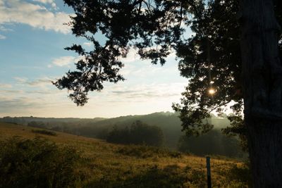
| Falling Waterfalls | 35.72194,-92.94944 | A main spot we visit since 2013. |
| Family Fun Pak | 34.47075,-93.0605 | A spot for the kids we visited, somewhat out of the way in Little Rock |
| Grinder's Ferry | 35.98493,-92.74401 | A good quick swimming spot, but can get crowded sometimes. |
| Gunner | 35.99417,-92.21083 | A spot we visited in June near Blanchard, not that much swimming wise. |
| Hardee's Mountain View (Near Blanchard) | 35.86522,-92.10908 | A Hardees not far from Blanchard we found on the fly . |
| Hardee's/Krispy Kreme Conway | 35.0668,-92.4406 | A Hardees and Krispy Kreme in Conway ` 1 hr from cabin. |
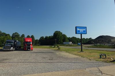
| Hotel, Rodeway Inn Halfway There | 33.9999,-93.18575 | A hotel outside of Prescott ARK we stayed at (one in Prescott was smoking). A restaurant, Southfork, next door. |
| Illinois Bayou (Gez Rogers) | 35.54487,-92.94935 | A new Gez Rogers spot, deep hole, I enjoyed it more in June vs July for some reason. |
| Mirror Lake Waterfall | 35.96384,-92.171283 | A non swimming waterfall in Blanchard, good fishing spot I'm told. |
| One Lane Bridge | 34.57724,-92.81155 | An out of the way quick spot we stumbled across outside Benton. |
| Pedestal Peak | 35.72371,-93.01443 | Hiking spot from 2013 near Falling Waterfalls. DIdn't finish as I left camera behind in vehicle. |
| Pizza Marshall ARK | 35.90805,-92.6649 | Pizza place in Marshall ARK. |
| Robertson Hole | 35.97083,-92.8794 | Good spot from 2021, road was closed 1� miles prior in 2024. |
| Shine Eye | 35.988,-92.7344 | Main good spot nearby, visited in years prior. |
| South Fork Nature Trail | 35.5555,-92.38661 | Hiking spot wife found on the fly from Archey, didn't enjoy, but may have been due to mood at the time. |
| South Maumee Access (Gez Rogers) | 36.04001,-92.63719 | Gez Rogers new spot near cabin, water was shallow. |
| St Joe's Railroad Museum | 36.0300165,-92.8024162 | Railroad museum near Robertsons, not open often. |
| Sulphur Springs (Gez Rogers) | 34.67313,-92.79858 | New Gez Rogers spot on way near Benton, half-decent (was better in June when water was higher). |
| Tyler Bend | 35.9892,-92.7675 | Scenic spot nearby near Shine Eye, water shallow but close-by and somewhat scenic. |
Note to self for future: POIs are in a sheet called "J_POIs_May2024" imported to map as "01_LRH." In this sheet there's a 2024 workbook with the spots visited in 2024, some may need to be added or updated, they're notated with an X to the right.)
[ "Mini Trip" Day 1 06-04-2024 ] |
[ "Mini Trip" Day 2, 06-05-2024 ] |
[ "Mini Trip" Day 3, 06-06-2024 ] |
[ "Mini Trip" Day 4, 06-07-2024 ] |
[ Day 0, 07-12-2024 (Fri) ] |
[ Day 1, 07-13-2024 (Sat) ] |
[ Day 2, 07-14-2024 (Sun) ] |
[ Day 3, 07-15-2024 (Mon) ] |

[ Day 4, 07-16-2024 (Tues) ] |
[ Day 5, 07-17-2024 (Wed) ] |

[ Day 6, 07-18-2024 (Thur) ] |
[ Day 7, 07-19-2024 (Fri) ] |
[ Page For KSG ] |
[ Jasper 2024, Highlights ] |
| comment | share |