


|
|
|
|
|
|
| lrh | profile | all galleries >> Jasper ARK Pictures >> Jasper, Spots (Documentation) | tree view | thumbnails | slideshow |
POIs In Table Format:
	All (One Long Listing) PDF (For Offline Viewing)

Google Maps
	My Custom Map PC Phone
	Gez Rogers

Offline GPS (Google Play Links)
	CoPilot
	Osmand
	Article

Possible Other POIs To Research Later (Added Aug 2024)
	Outside POIs Page (Good for Coming Up With a New POIs Design
	Illinois RV River and Campground, new spot found in Aug 2004 that has a lot in one place & may be worthwhile (already in POIs table and map)
	Sylamore Swinging Bridge, Bridge/Swimming Hole Near Mountain View
	Gez Rogers Facebook, an excellent source & the source of the 2024 map which had Archey Fork and Illinois Bayou etc
	Chester City Park, apparently a spot much like Bradley Park
	Waterfall Map
	Natural Dam (may already have it from swimmingholes.org), an easy to get to swing rope swim area
How To:Import POIs from spreadsheet into here
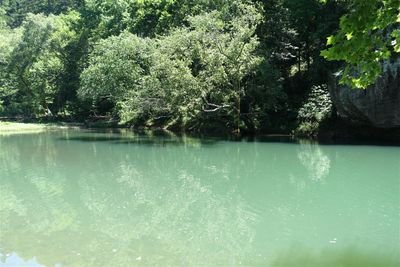
This is an image I took in 2015 at "Whiteley Hole," it's one of my best shots from all of the trips.
 A thorough documentation & listing of the spots we've visited. (I have a 2021 "quick" version here and a new, 2024 version here.)
Jasper ARK is a scenic small town located in the "Ozarks" of Northwest Arkansas. We found out about it during research for our upcoming 2012 vacation. My wife wanted to visit her grandfather, who lived in Butler MO, but there was nothing I liked in the area. She got him to agree to meet us for a day in Branson. I found out about this region and how it was only an hour away from Branson, enabling us to vacation here and then to vist him in Branson on a particular given day. It had what I wanted--scenic swimming holes in a quiet area (not a large "tourist trap" area like, say, Orlando FL) where I could enjoy the water but also get good landscape shots in a quiet area. We liked it so much, we have returned most years since, and are about to visit again in 2024 as I write this.
This page is a documentation of our favorite spots, including a listing at the bottom of this page of almost every "saved" spot we have on file, in table format (as well as a custom "My Maps" in Google Maps of the spots.
I initially found these spots via the "Jasper" section of the website swimmingholes.org, a site I've used for many years (our honeymoon spot in Dec 2000 was also found there). Afterwards, later in 2012 I believe, I purchased a book called Swimming Holes of the Ozarks by Glenn Wheeler, a book which was sold in the ranger station. You can buy it in book-form here or download a PDF of it here. I also found some spots "on the fly" or from the original cabin owners, Michelle/Jeff Lawson.
I document the spots via GPS coordinates, in "decimal degrees" format, whereby they look something like 35.21,-92.13. (This format seems to be the best for using in Google Maps, whereas the degrees-minutes-seconds, which is how the spots were originally documented in the book, seems to be the "native" format of Garmin Nuvi units.) It's sort of similar to what one may call a "dropped pin." This is invaluable given that many of these points of interests can be located in areas which have spotty cellphone service and these spots don't always have "official" names attached to them, such as "Wendy's Shreveport LA," meaning they'd likely be tricky to find in a routine search.
The usage of GPS coordinates also made it easy in the first year to backup locations I found and saved "on the fly" to our Garmin Nuvi, as I used such a unit (as opposed to a phone) extensively the first couple of years, as my cellphone (Virgin Mobile) had no service in the area. (I switched to Cricket/AT&T in 2015, which did have service in many of the areas.) This way, the spots weren't "locked" into the machine, which I figured would become lost or replaced later on. (I elaborate a bit more on GPS coordinates here.
Starting in 2015 I created a custom Google "My Maps" with my own POIs documented as a map, you can get it here. I have created a quick summary of some of our favorite spots, and provided a complete listing of the spots as a table, this table is being updated rather regularly.
In the custom map, you will notice that the "notes" section of each spot has the GPS coordinates (so you can know the details of where it is in a way to where you could "plug" the spot into an offline GPS if need be). The table listing also has the GPS coordinates listed. (The coordinates are in "decimal degrees" format, to convert them to the degrees/minutes/seconds format this is a conversion tool you can use.)
In 2024 my wife sent me a map she found by someone named "Gez Rogers," (link) and it contained a whole punch of POIs which were well documented and organized, better than what I'd done. They even link to YouTube videos of each spot so you can get a good idea about it beforehand. It's very well done. I successfully copied and saved this map for myself and was able to integrate it into my pre-existing map (all my links are now basically in 1 "layer" and are mostly all-black, while theirs are in multiple layers the same as in the original).
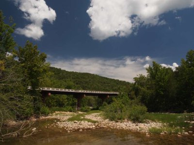
Ponca Low Water Bridge. (GPS coordinates: 36.01870,-93.35710 link). We found this one by accident "on the fly," yet (as we later found out) it was mentioned both in the book and at swimmingholes.org. Some of my best photos have been taken here, and the water here for cooling off is most-times top notch. You have a low bridge that's maybe 6 ft above the water and it's absolutely ideal for jumping in, as many do.
Blue Hole. (GPS coordinates: 35.99478,-93.0420 link). This is one that the original cabin owners (Jeff & Michelle Lawson) told us about, giving us non GPS-based driving directions (that somehow we got dead-on right), but as with Ponca it's mentioned in the book (Troy Eddings). (Needless to say, we saved it as a favorite, the coordinates shown are NOT the final destination parking-wise, which is about another 2-odd miles down the path, but it's where you pull off the road to begin.) Unlike many other spots, it's consistently deep no matter the rain activity, and many of my best landscapes have been taken here.Bradley Park.. (GPS coordinates: 36.00387, -93.19468 link). I forget how I found out about this one, but it's one I would've found out about because it's right in town at the city park in Jasper. This is one I visit alone a lot of times. It's good for a "quick dip" where it isn't like you're making a trip per se, but rather it's something you could do while running mundane errands such as picking up some groceries. It has good swimming and I've gotten some good landscape shots here, and then I can go back to the cabin very quickly.
Falling Waterfalls.. (GPS coordinates: 35.72194, -92.94944 link). We first visited this during our short 2013 visit, we saw it in the book (which we'd just bought at the time, our 1st year the spots we found were via swimmingholes.org). It is a commonly cited top-notch hole by the book and by other sites I've visited. You have a small waterfall which makes the water seem vibrant and you can jump in from atop the waterfall, and the water tends to be a bit cooler. The only downside is having to drive 2-odd miles down a semi-rutty path, but most times it's not so objectionable. It's one of our favorites and most times a can't miss.
Robertson. (GPS coordinates: 35.97083,-092.8794 link). This is a spot that we'd seen in the book for sometime but didn't actually go to until 2021, to help kind of "freshen things up" as it were. It was well liked by all of us, with plenty deep water and spots for jumping, and it feels even more secluded than other spots.
Crow Hole. (GPS coordinates: 36.063476, -93.127216 link). This was a spot in the Jasper area that some people told us about one day around 2017 while we were eating at Subway. I mainly saved it for future reference, but then we actually went in 2021 (and again in 2022). It was a favorite due to being exceptionally remote, well shaded for the wife, and with a rope swing for the kids. However, it does involve a small amount of driving on some rutty roads.
Longpool. (GPS coordinates: 35.55,-93.1622 link). A spot from the book, first went to in 2015 or 2016, and again in 2021. It has a good jumping platform and is easy to get to, with close parking.
Carver. (GPS coordinates: 35.98419,-93.04162 link). This is not an enjoyable spot swimming-wise, but it's easy to get to & it makes for really good scenic photos. One of my favorites from 2012 was taken here. It's near Blue Hole, a favorite, we ran into it "on the fly" while going to the Blue Hole. I tend to stop here mainly if I'm already going to the Blue Hole or such and want a "quickie" visit which will give me good scenic shots.
Sam's Throne. (GPS coordinates: 35.87904, -93.0448 link). A short-hiking spot with good "bird's eye views," as the other spots, as much as I liked them, didn't provide the high-altitude bird's eye views I was also wanting. The cabin owners in 2012 told us of this spot, and we often-times combine it with trips to Falling Water Waterfalls as it's somewhat in the area, and we would eat at the nearby cafe (it was called Eagle Rock Cafe, then Lighthouse, but last I checked it was now closed, not sure if there's anything else in its place {870) 434-5800 mjlighthousecafe@hotmail.com}).
Illinois Bayou Swim Hole. (GPS coordinates: 35.54487,-92.94935 link). A new "Gez Rogers" spot for 2024, it has two spots--the one shown, it has a very large deep area with a jumping platform, but when we were there it was overrun by undesirables. Another spot about 0.2 prior on the right has a smallish deep area but is much more private and scenic, my wife preferred it.
Archey Fork. (GPS coordinates: 35.64558,-92.52582 link). A new "Gez Rogers" spot for 2024, it quickly became a favorite. (The coordinates shown are "parking" coordinates, the coordinates of the actual spot: 35.64321,-92.52218.) It has a good sized deep hole with fewer hard rocks, a swing rope, a spot on a rock for jumping, and even a zip line setup (further down to the right, you can see it from the jumping rock).
Here is a detailed POIs table made as of July 28th 2024. The GPS coordinates are clickable maps links and are shown in decimal degrees format (you can see them in "degrees, minutes, seconds" format by clicking here). You can also download this table as a PDF file (which would allow you to have this information offline) by clicking here.
|
[ Jasper, "Quick" POIs (2021) ] |
[ Import POIs Into PBase ] |
[ Jasper Points of Interest, Tables, All ] |
[ Archey Fork, Blufton Preserve ] |
[ Ponca Access ] |
| comment | share |