


|
|
|
|
|
|
| lrh | profile | all galleries >> Jasper ARK Pictures >> Jasper, Spots (Documentation) >> Archey Fork, Blufton Preserve | tree view | thumbnails | slideshow |
Archey Fork, Blutton Preserve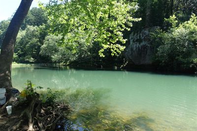
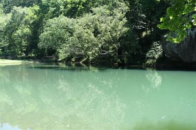
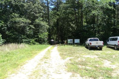
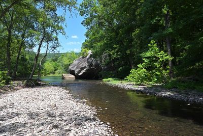
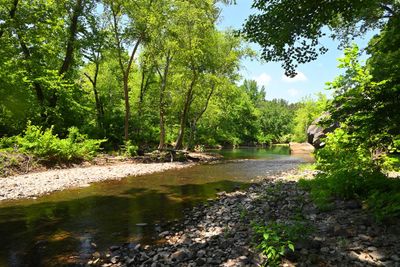
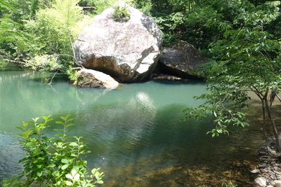
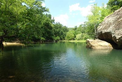
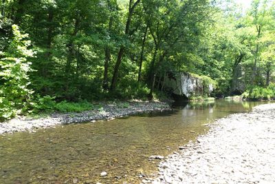
Home City: Clinton ARK GPS: Park 35.645580, -92.525820 link Spot 35.64321, -92.52218 link Shade: Excellent Proximity to Food/Gas: ~ 15 Minutes (Clinton) How We Found It: A new map (Gez Rogers) my wife found in 2024. Fee: No Years Visited: 2024 Smoothness Of Road: Yery Good Photo Gallery: Here Video: Gez Rogers YouTube Pros: Scenic, cool water, secluded, hiking in same area, good jumping, well shaded, good fishing, smooth easy road, reasonably close to food places etc. Cons: Not close (best as I can tell) to other attractions, sort of "to itself" somewhat Grade: A+ Archey Fork, which is what I call it, is probably best called "The Bluffton Preserve at the Archey Fork." It is a spot we found anew in 2024 from the "Gez Rogers" map my wife had sent me prior, it showed up as a spot on the way in from our home to the cabin. We'd meant to check it out on the way in during our "mini" June trip, we didn't, but we checked it out on the way home. Archey Fork is outstanding; as of when I write this in Oct 2024, it's the clear #1 for us both. The swimming is first-rate, getting deep quickly (and staying that way), with various spots suitable for jumping, a swing rope, and even a crudish zip line (look down the waterway to your right once you're by the water). It makes for great scenic shots, and when we took our friend Kevin there in 2024, a guy who is HUGE into fishing, he caught lots of fish too. It's also well shaded, a consideration for us as we age into our 40s and 50s. Note: once you park, and have walked about 0.2 miles or so, you will come to the spot where you want to bear right. You could instead keep going straight, but that spot, while more popular, is inferior in my opinion compared to the one we found (shown above in the GPS coordinates). You can click here to see photos of the day we visited, which shows how you accomplish this. The drive consists of about 4 miles down a gravelish road (Watergate, off 65), but it's hardly in bad shape, and even our low-profile Toyota Corolla rental in 2024 handled it with ease. About 2/3rds of the way in the road "bears" right a little, it's somewhat easy to instead "bear" left, which you don't want to do, but this become quickly obvious even to me, and I suck at directions. There are also hiking trails on the way in as well, which as of this writing we haven't checked out, although I'm told they're excellent. There is also a neat spot little hiking/natural bridge spot nearby called Natural Bridge (link), maybe something else to combine with a trip to here (it's on the way into Clinton if you're eating there). You will be about 20 minutes away from Clinton, which has a few places for eating and gassing up your car, always a consideration for any point of interest in my opinion (again the Natural Bridge Spot will be right on the way too). There are also a couple of places in Leslie, and if you're staying in Marshall (as we did in 2024) it's somewhat more "on the way" back to your cabin (whereas the Clinton eating spots will be a little out of the way). ----------- Nearby Gas/Food Clinton Mexican Restaurant 35.60169,-92.46274 (link) 20 min S Huddle House (link) Western Sizzlin {All You Can Eat} (link) Exxon (link) Leslie Red River Cafe (link) 25 min N Misty's Convenience (link) Dollar General (link) |
 The Spot |
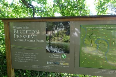 Archey Fork Sign |
 The "Wrong" Entrance |
 Archey Fork, Retouched Photo |
 Archey Fork, Retouched Photo |
 Archey Fork, Entrance |
 Archey Fork, Side View |
 Archey Fork, Side View To The Right |
| comment | share |