


|
|
|
|
|
|
| |
| 26-OCT-2006 | Dave Beedon |
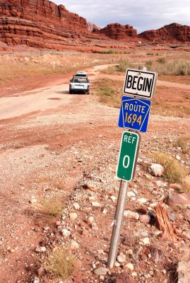
Location: near the Potash boat ramp, looking north. On this side of the
sign the road has no name signage. On the far side is Federal Route 1694.
The two side roads are turn-offs for the parking lot of the boat ramp. As of
Spring 2012 and possibly earlier, the closer turn-off had been permanently
blocked as part of a re-building of the boat ramp facility. Beyond the car,
the road is covered with sand washed there by recent heavy rain.
.
| Full EXIF Info | |
| Date/Time | 26-Oct-2006 10:44:54 |
| Make | Nikon |
| Model | NIKON D80 |
| Flash Used | No |
| Focal Length | 28 mm |
| Exposure Time | 1/320 sec |
| Aperture | f/13 |
| ISO Equivalent | 400 |
| Exposure Bias | 0.67 |
| White Balance | |
| Metering Mode | matrix (5) |
| JPEG Quality | |
| Exposure Program | manual (1) |
| Focus Distance | |
All images are copyright 1966 - 2023 by Dave Beedon (davebeedon AT comcast DOT net).