


|
|
|
|
|
|
| |
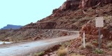
| 26-OCT-2006 | Dave Beedon |
Location: near the Potash boat ramp, looking south. The parking lot of
the boat ramp is at far left. This is the end of Federal Route 1694,
as indicated by the barely visible sign on the far side of the road.
The next image shows the sign in detail, looking in the opposite direction.
To the right are two signs. The larger sign was posted by Moab Salt,
the previous name of the company operating the potash mine here.
The name is now "Intrepid Potash, LLC." The sign describes the road
ahead and mentions that it travels through the mine's private property.
An identical sign is posted a few miles farther down the road.
The smaller sign erroneously indicates the start of San Juan County
Road 142. This picture was taken in 2006. As of 2009, the sign had
been moved about 0.6 miles farther down the road to its correct
position at the boundary between Grand and San Juan counties.
I have yet to determine an official name for the road between this
point and the county line up ahead. I might be the only person who cares.
This scene is at the center of this WikiMapia aerial view.
.
All images are copyright 1966 - 2023 by Dave Beedon (davebeedon AT comcast DOT net).