


|
|
|
|
|
|
| |
| 01-Oct-2011 | AKMC |
We jumped in the car and continued west until we reached a sign telling us of the 12 Apostles Caravan Park, and various other things related to the said Apostles. Never having been in the area before we took the signs at their word, only to end up in a rather small township which I now know to be... Princetown. We were in fact still about 6km short of the Apostles, but could do with the break anyway.
(For reference, as the crow flies Princetown is about 25Ks north west of the Castle Cove lookout which was the site of the preceding photos. However the road heads inland via the Melba Gully National Park and so it's about 43km by road, or about 40 minutes. The previous published photo was taken about 50 minutes earlier.)
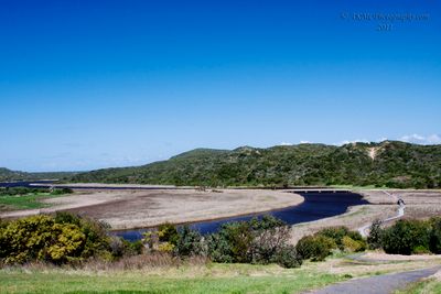
This is, I believe, looking down the estuary of the Gellibrand River. The wetlands are home to a range of birdlife. Had we not been on a tighter timeline than I would have liked, it would have been interesting to follow the path and see how close to the ocean it would have taken us. However I suspect that it would be a good couple of hours to follow it all the way.
-----
Edit September 2024: I believed it was the Gellibrand River then, I know it now. And, it seems, I overestimated the time it would have taken, not that we had the time anyway. Google Maps has a marker on the maps these days; "Princetown Wetlands Boardwalk". From the Visit12Apostles.com.au web site:
"The Princetown Boardwalk restores a historic link from the township to the recreation reserve and river mouth. It also connects the town to a lovely picnic area and fishing platform near a bridge over the Gellibrand River.
Princetown’s new viewing platform provides a great perch to view birdlife and kangaroos on the estuarine river flats below the township.
[*] Length: 600m including connective trail
[*] Time: 25 minutes
[*] Where: Commence from viewing platform on Post Office Road Princetown, 18km east of Port Campbell
As we'll see, Post Office Road is where we were at the time. Again, though, this is probably something better done out of Port Campbell than Apollo Bay.
©2000-2024 AKMC. May not be used, copied or reproduced or used in AI training without written permission, especially by Facebook