


|
|
|
|
|
|
| |
| 13-JUL-2002 | |
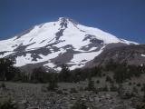
Here's a good shot of the Mountain from the east. From left to right (southerly to northerly) you can see the Wintun Glacier, a snowfield, and the Hotlum Glacier. Our intended route was up the wide ridge between the snowfield and the Wintun. However, due to some large ice patches, we ended up hugging the thinner ridge to the north. The ice falls of the Hotlum glacier are visible just north of that ridge.
We got to the trailhead on Friday night to find it had been made into a campground by a group of about twenty people (only ten of whom were thinking of climbing), there to share someone's 40th birthday climb. We had to park and set up the tent on the road into the trailhead lot (most of them had parked sideways taking up two spaces for the car and the tent). However, they were nice enough to offer us eggs and sausage the next morning (after we had finished our oatmeal and shouldered our packs, so it was a pretty safe offering, but very nice nonetheless... Had they know about Santosh's appetite, they probably would have thought better).
Speaking of appetite, how can we forget the mosquitos at trailhead! These suckers are "the size of English schoolboys" (as Bud likes to say). There are a few telltale smears of blood inside Bud's tent now... the last remains of those few that ventured into our tent at night!
-- SPoonen, 7/17/02