


|
|
|
|
|
|
| |
| 26-OCT-2006 | Dave Beedon |
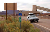
Location: Potash, looking south. On this side of the sign the road is SR 279
(Potash Road0; on the far side it is Federal Route 1694. Route 1694 runs for
1.5 miles (2.4km) to its end by the Potash boat ramp. "Ref 5" is supposedly a distance
indicator. Near the building in the background is the entrance to the potash mine.
This sign is located at the center of this WikiMapia aerial view.
.
| Full EXIF Info | |
| Date/Time | 26-Oct-2006 10:52:02 |
| Make | Nikon |
| Model | NIKON D80 |
| Flash Used | No |
| Focal Length | 34 mm |
| Exposure Time | 1/500 sec |
| Aperture | f/8 |
| ISO Equivalent | 200 |
| Exposure Bias | |
| White Balance | |
| Metering Mode | matrix (5) |
| JPEG Quality | |
| Exposure Program | manual (1) |
| Focus Distance | |
All images are copyright 1966 - 2023 by Dave Beedon (davebeedon AT comcast DOT net).