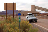
photo sharing and upload picture albums photo forums search pictures popular photos photography help login
Dave Beedon | all galleries >> Places >> Utah >> Moab (environs) >> Potash Area >> Official Naming of Roads Near Potash > Potash Road ends and Federal Route 1694 begins
previous | next
26-OCT-2006 Dave Beedon

Potash Road ends and Federal Route 1694 begins

Potash, Utah (near Moab)

Location: Potash, looking south. On this side of the sign the road is SR 279
(Potash Road0; on the far side it is Federal Route 1694. Route 1694 runs for
1.5 miles (2.4km) to its end by the Potash boat ramp. "Ref 5" is supposedly a distance
indicator. Near the building in the background is the entrance to the potash mine.


This sign is located at the center of this WikiMapia aerial view.

.

Nikon D80 ,Nikkor 28-105mm f/3.5-4.5D AF
1/500s f/8.0 at 34.0mm iso200 full exif

other sizes: small medium large auto
previous | next
share
Type your message and click Add Comment
It is best to login or register first but you may post as a guest.
Enter an optional name and contact email address. Name
Name Email
help private comment