


|
|
|
|
|
|
| |
| 14-OCT-2006 | Dave Beedon |
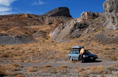
My route to the summit followed a zigzag line in the left half on this view. The area
behind my car was a quarry at one time, possibly supplying rock for the construction
of a causeway on the island's southeast side. Note the bulldozer tread marks in the
dark gray gravel at left.The lines in back of my car show up in another photo.
My car is at the crosshair of this WikiMapia aerial photo:
http://www.wikimapia.org/#y=40920582&x=-113632193&z=14&l=0&m=a&v=2 .
.
All images are copyright 1966 - 2023 by Dave Beedon (davebeedon AT comcast DOT net).
| 1moremile | 04-Jun-2007 23:48 | |
| Jason Anderson | 25-May-2007 22:03 | |
| Lee G | 25-Apr-2007 02:11 | |
| Monte Dodge | 25-Apr-2007 01:38 | |