


|
|
|
|
|
|
| |
| 9 Jul 2004 | Dave Beedon |
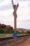
Near Jug Handle Arch a dirt road branches to the west and ascends Long Canyon, leading
to the plateau upon which Dead Horse Point State Park sits. The road is a popular
mountain bike route (especially for the descent from the plateau to the river).
This sign marks the grade crossing at the junction of the road and the track.
The Colorado River is to the left, between the green bushes and the rock cliff.
All images are copyright 1966 - 2023 by Dave Beedon (davebeedon AT comcast DOT net).