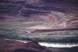
The Colorado River is flowing from right to left. The road just above it, signed as "Federal Route 1694," comes from Moab to the right and goes to the Potash boat ramp (just out of view to the left). It is casually (and erroneously) called either "Potash Road" or "Shafer Trail."
The road curves around the southern end of the Union Pacific Railroad's Cane Creek Branch, a branch line that serves the potash mine here. Everything above the river id property of Intrepid Potash, the company that owns and operates the potash mine here.
Photographed from the "Jackson-Kane Plateau" (my name for a ridge of sorts lying between Jackson's Hole and Kane Springs Canyon). A similar shot, made from a slightly different angle on a sunny day, appears in the comment below.
|