Dave Beedon
|
all galleries
>>
Places
>>
Utah
>>
Moab (environs)
>>
4922 Plateau
> Culvert Canyon and Amasa Back
previous
|
next
01-MAY-2015
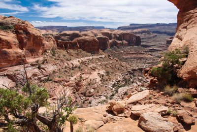
Culvert Canyon and Amasa Back
view map
The pour-off here is a sheer drop of about 80 feet (25 m). The terrain below is part of Culvert Canyon.
The undulating plateau at upper center is composed of domes above Corona Arch, Bow Tie Arch, and Pinto Arch (all are on the far side of the plateau).
Just to the right of the plateau is a gap---that's the mouth of Culvert Canyon. Visible through the gap is the northern end of Amasa Back.
Nikon D80
1/800s f/7.1 at 18.0mm iso200
full exif
other sizes:
small
medium
large
original
auto
previous
|
next
All images are copyright 1966 - 2023 by Dave Beedon (davebeedon AT comcast DOT net).
share
Type your message and click Add Comment
It is best to
login
or
register
first but you may post as a guest.
Enter an optional name and contact email address.
Name
Name
Email
help
private comment
Type your message and click Add Comment
It is best to
login
or
register
first but you may post as a guest.
Enter an optional name and contact email address.
Name
Name
Email
help
private comment