photo sharing and upload picture albums photo forums search pictures popular photos photography help login
Dave Beedon | all galleries >> Places >> Utah >> Moab (environs) >> 4922 Plateau > Curving rock
previous | next
01-MAY-2015

Curving rock

view map

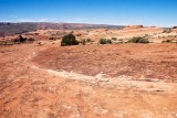
The light-colored foreground rock made me wonder. Is it the remnant of a dome? a sand dune? a petrified flying saucer?

This is on an are I call "4922 plateau," named after the highest elevation that appears on topographic maps. It is a bit off the beaten track and is reached via a short but steep scramble. I saw no trace of human visitation.

My vantage point was at the center of this WikiMapia aerial view.

Nikon D80
1/250s f/14.0 at 18.0mm iso200 full exif

other sizes: small medium large original auto
share
Type your message and click Add Comment
It is best to login or register first but you may post as a guest.
Enter an optional name and contact email address. Name
Name Email
help private comment