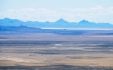
This view looks south-southwest from the summit of Point 5363, a mountain on Utah�s SR 30. The Sun Tunnels, 9.5 miles distant, are dark specks just barely visible in the original-size image, under the small white dot in the brown landscape, right of center.
The light-colored lines at lower left belong to the airfield east of Lucin.
The low, dark ridge at far left is Lemay Island.
The distant range is the Silver Island Mountains. The pyramid-shaped peak just right of center is Rishel Peak, 43 miles away. To its right, and slightly lower, is Volcano Peak.
Zoom lens was set to 200mm.
|