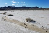
During my handcart hikes on the mud flats of Crater Island I saw numerous examples of animal travel, mostly tracks like these. Were the animals looking for water in the lowest part of the flat? These tracks were made when the mud was uniformly moist. I'd guess they were made by pronghorns.
One would imagine that a mud flat was smooth and flat, right? I certainly did before I ever set foot on this one. It might be smooth and flat at its lowest point, but all around that the ground slopes ever-so-gently downhill toward the low point. I crossed many drainage channels like the one shown here. Memory tells me that all were less than three inches (8cm) deep and most about one inch (2.5cm) deep. Vegetation mounds were all over the place, but in the greatest concentration along the �shore.�
Geo-tagging is approximate.
|