


|
|
|
|
|
|
| lrh | profile | all galleries >> Jasper ARK Pictures >> Jasper, Spots (Documentation) | tree view | thumbnails | slideshow |
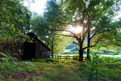
This is an image I took in 2015 at "Whiteley Hole," it's one of my best shots from all of the trips.
Jasper ARK is a scenic small town located in the "Ozarks" of Northwest Arkansas. We found out about it during research for our upcoming 2012 vacation. My wife wanted to visit her grandfather, who lived in Butler MO, but there was nothing I liked in the area. She got him to agree to meet us for a day in Branson. I found out about this region and how it was only an hour away from Branson, enabling us to vacation here and then to vist him in Branson on a particular given day. It had what I wanted--scenic swimming holes in a quiet area (not a large "tourist trap" area like, say, Orlando FL) where I could enjoy the water but also get good landscape shots in a quiet area. We liked it so much, we have returned most years since, and are about to visit again in 2024 as I write this.
This page is a documentation of our favorite spots, including a listing at the bottom of this page of almost every "saved" spot we have on file, in table format (as well as a custom "My Maps" in Google Maps of the spots.
I initially found these spots via the "Jasper" section of the website swimmingholes.org, a site I've used for many years (our honeymoon spot in Dec 2000 was also found there). Afterwards, later in 2012 I believe, I purchased a book called Swimming Holes of the Ozarks by Glenn Wheeler, a book which was sold in the ranger station. You can buy it in book-form here or download a PDF of it here. I also found some spots "on the fly" or from the original cabin owners, Michelle/Jeff Lawson.
I document the spots via GPS coordinates, in "decimal degrees" format, whereby they look something like 35.21,-92.13. (This format seems to be the best for using in Google Maps, whereas the degrees-minutes-seconds, which is how the spots were originally documented in the book, seems to be the "native" format of Garmin Nuvi units.) It's sort of similar to what one may call a "dropped pin." This is invaluable given that many of these points of interests can be located in areas which have spotty cellphone service and these spots don't always have "official" names attached to them, such as "Wendy's Shreveport LA," meaning they'd likely be tricky to find in a routine search.
The usage of GPS coordinates also made it easy in the first year to backup locations I found and saved "on the fly" to our Garmin Nuvi, as I used such a unit (as opposed to a phone) extensively the first couple of years, as my cellphone (Virgin Mobile) had no service in the area. (I switched to Cricket/AT&T in 2015, which did have service in many of the areas.) This way, the spots weren't "locked" into the machine, which I figured would become lost or replaced later on. (I elaborate a bit more on GPS coordinates here.
Starting in 2015 I created a custom Google "My Maps" with my own POIs documented as a map, you can get it here. I have created a quick summary of some of our favorite spots, and provided a complete listing of the spots as a table, this table is being updated rather regularly.
In the custom map, you will notice that the "notes" section of each spot has the GPS coordinates (so you can know the details of where it is in a way to where you could "plug" the spot into an offline GPS if need be). The table listing also has the GPS coordinates listed. (The coordinates are in "decimal degrees" format, to convert them to the degrees/minutes/seconds format this is a conversion tool you can use.)
In 2024 my wife sent me a map she found by someone named "Gez Rogers," (link) and it contained a whole punch of POIs which were well documented and organized, better than what I'd done. They even link to YouTube videos of each spot so you can get a good idea about it beforehand. It's very well done. I successfully copied and saved this map for myself and was able to integrate it into my pre-existing map (all my links are now basically in 1 "layer" and are mostly all-black, while theirs are in multiple layers the same as in the original).
Ponca Low Water Bridge. (GPS coordinates: 36.01870,-93.35710 link). We found this one by accident "on the fly," yet (as we later found out) it was mentioned both in the book and at swimmingholes.org. Some of my best photos have been taken here, and the water here for cooling off is most-times top notch. You have a low bridge that's maybe 6 ft above the water and it's absolutely ideal for jumping in, as many do.
Blue Hole. (GPS coordinates: 35.99478,-93.0420 link). This is one that the original cabin owners (Jeff & Michelle Lawson) told us about, giving us non GPS-based driving directions (that somehow we got dead-on right), but as with Ponca it's mentioned in the book (Troy Eddings). (Needless to say, we saved it as a favorite, the coordinates shown are NOT the final destination parking-wise, which is about another 2-odd miles down the path, but it's where you pull off the road to begin.) Unlike many other spots, it's consistently deep no matter the rain activity, and many of my best landscapes have been taken here.Bradley Park.. (GPS coordinates: 36.00387, -93.19468 link). I forget how I found out about this one, but it's one I would've found out about because it's right in town at the city park in Jasper. This is one I visit alone a lot of times. It's good for a "quick dip" where it isn't like you're making a trip per se, but rather it's something you could do while running mundane errands such as picking up some groceries. It has good swimming and I've gotten some good landscape shots here, and then I can go back to the cabin very quickly.
Falling Waterfalls.. (GPS coordinates: 35.72194, -92.94944 link). We first visited this during our short 2013 visit, we saw it in the book (which we'd just bought at the time, our 1st year the spots we found were via swimmingholes.org). It is a commonly cited top-notch hole by the book and by other sites I've visited. You have a small waterfall which makes the water seem vibrant and you can jump in from atop the waterfall, and the water tends to be a bit cooler. The only downside is having to drive 2-odd miles down a semi-rutty path, but most times it's not so objectionable. It's one of our favorites and most times a can't miss.
Robertson. (GPS coordinates: 35.97083,-092.8794 link). This is a spot that we'd seen in the book for sometime but didn't actually go to until 2021, to help kind of "freshen things up" as it were. It was well liked by all of us, with plenty deep water and spots for jumping, and it feels even more secluded than other spots.
Crow Hole. (GPS coordinates: 36.063476, -93.127216 link). This was a spot in the Jasper area that some people told us about one day around 2017 while we were eating at Subway. I mainly saved it for future reference, but then we actually went in 2021 (and again in 2022). It was a favorite due to being exceptionally remote, well shaded for the wife, and with a rope swing for the kids. However, it does involve a small amount of driving on some rutty roads.
Longpool. (GPS coordinates: 35.55,-93.1622 link). A spot from the book, first went to in 2015 or 2016, and again in 2021. It has a good jumping platform and is easy to get to, with close parking.
Carver. (GPS coordinates: 35.98419,-93.04162 link). This is not an enjoyable spot swimming-wise, but it's easy to get to & it makes for really good scenic photos. One of my favorites from 2012 was taken here. It's near Blue Hole, a favorite, we ran into it "on the fly" while going to the Blue Hole. I tend to stop here mainly if I'm already going to the Blue Hole or such and want a "quickie" visit which will give me good scenic shots.
Sam's Throne. (GPS coordinates: 35.87904, -93.0448 link). A short-hiking spot with good "bird's eye views," as the other spots, as much as I liked them, didn't provide the high-altitude bird's eye views I was also wanting. The cabin owners in 2012 told us of this spot, and we often-times combine it with trips to Falling Water Waterfalls as it's somewhat in the area, and we would eat at the nearby cafe (it was called Eagle Rock Cafe, then Lighthouse, but last I checked it was now closed, not sure if there's anything else in its place {870) 434-5800 mjlighthousecafe@hotmail.com}).
Illinois Bayou Swim Hole. (GPS coordinates: 35.54487,-92.94935 link). A new "Gez Rogers" spot for 2024, it has two spots--the one shown, it has a very large deep area with a jumping platform, but when we were there it was overrun by undesirables. Another spot about 0.2 prior on the right has a smallish deep area but is much more private and scenic, my wife preferred it.
Archey Fork. (GPS coordinates: 35.64558,-92.52582 link). A new "Gez Rogers" spot for 2024, it quickly became a favorite. (The coordinates shown are "parking" coordinates, the coordinates of the actual spot: 35.64321,-92.52218.) It has a good sized deep hole with fewer hard rocks, a swing rope, a spot on a rock for jumping, and even a zip line setup (further down to the right, you can see it from the jumping rock).
Here is a detailed POIs table made as of June 10th 2024. The GPS coordinates are clickable maps links and are shown in decimal degrees format (you can see them in "degrees, minutes, seconds" format by clicking here). You can also download this table as a PDF file (which would allow you to have this information offline) by clicking here.
| Spot | GPS Coordinates | Type | Source | Description |
|---|---|---|---|---|
| Alfred Fountain Grocery | 35.7205,-92.82393 | FG | O | New grocery store found in 2024 in research. |
| Alley Spring Campground p154 | 37.1506,-91.45111 | S | B | A `plugged Missouri spot from the book we've never been to. |
| Alum Cove (p39T) | 35.8576,-93.2346 | HK | B | Small quiet hiking spot visited in 2015, told about it by Dogwood Springs owners, it's also in the trails book. |
| America's Best Value Inn Prescott ARK | 33.8103, -93.4197 | MC | O | Hotel en route which we stayed at in 2018 which has a half-decent pool. |
| Archey Fork Bluffton Preserve, PARK | 35.64558,-92.52582 | S | GR | New spot for 2024, a really good one. Coordinates are parking, the spot is at 35.64321,-92.52218 |
| Archey Fork Bluffton Preserve, THE SPOT | 35.64321,-92.52218 | S | GR | The actual best spot for Archey, has a rope swing, small rock you can jump off of, and even a zip line setup. Basically it's the spot right of the `camping` spot, with a smooth entrance vs a sharp dropoff. |
| Atlanta TX BBQ | 33.12315,-94.17950 | FG | O | A BBQ place we found on the fly in 2012 and ate at, also in 2013. |
| Baptist Camp, Big Piney River p144 | 37.2583, -92.0186 | S | B | A spot near Houston MO which wife wanted to go to, other spots from book in area. |
| Barkshed p52 | 36.0192, -92.25083 | S | B | Not sure if we've ever been there. |
| Barn Shot 74 | 36.00961,-93.30047 | LM | O | THE barn shot I regularly take a photo of (found "on the fly" in 2012). |
| Barn Shot ARK 21 During 2018 | 36.0983,-93.14678 | LM | O | Barn shot I took in 2018 detouring around road construction near ARK 21 |
| Barn Shot Falling Waterfalls | 35.93986,-93.10139 | LM | O | Barn shot I took sometime near Falling Waterfalls. |
| Barn Shot, 2018 #3 | 34.6118,-92.73879 | LM | O | Barn shot taken in 2018 on way home (scenic detour?). |
| Barn shot, Scenic Detour #1 | 34.61201,-92.73925 | LM | O | Location of barn shot I took in 2018 on "scenic detour." |
| Barn shot, Scenic Detour #2 | 34.88149,-92.7735 | LM | O | Location of barn shot I took in 2018 on "scenic detour." |
| Bathhouses (sh.org) | 34.51240,-93.05393 | S | W | Spot "plugged" from swimmingholes.org, never visited. |
| Bayou Bluff p 42 | 35.52389,-92.9425 | S | B | Visited in 2020, wasn't that much (water levels?). |
| BBQ Eating Place (Slims) Near Falling Waterfalls | 35.67476,-92.95053 | FG | O | BBQ place wife found on the fly near Falling Waterfalls area. `Country` sounding music playing, wife liked BBQ sandwich, I bought bottle of sauce. |
| Benton (sh.org) | 34.6056,-92.6192 | S | W | A river spot on the way in Benton ARK, have stopped twice but it wasn't much, might be in years where it's rained a lot. |
| Big Hole? (p30) | 35.8044, -93.55611 | S | B | 4 Wheel Drive Needed, never been. |
| Big Pinkey Creek Limestone | 35.787552, -93.3612 | S | O | Added in 2017, but don't think we've ever visited it, not sure where we found it. |
| Big Spring Hole Current River p170 | 36.9514,-90.9906 | S | B | A `plugged Missouri spot from the book we've never been to. |
| Big Spring p50 | 36.2661,-92.5431 | S | B | Swim hole in town with rope swing, was too shallow for me, but kids usually like it. |
| Big Tree p172 | 36.925,-90.9022 | S | B | A `plugged Missouri spot from the book we've never been to. |
| Blakely Dam (sh.org) | 34.56874,-93.19470 | S | W | Spot "plugged" from swimmingholes.org, never visited. |
| Blanchard, Lower (p56) | 35.9681, -92.1792 | S | B | A cluste of spots we should be visiting in 2024, also includes caverns. |
| Blanchard, Upper (p56) | 35.9731, -92.1772 | S | B | A cluste of spots we should be visiting in 2024, also includes caverns. |
| Blue Hole 2024 | 35.521475,-92.880437 | S | O | Spot wife found in 2024 research, to check out if possible. |
| Blue Hole Victor 1 of 2 | 35.6498,-93.0027 | S | GR | Spot found by wife on the fly in 2024 which turns out was in fact a pre-existing Gez Rogers spot, only our spot was a dud, this one seemed to be good, 1 of 2. |
| Blue Hole Victor 2 of 2 | 35.6506,-93.0055 | S | GR | Spot found by wife on the fly in 2024 which turns out was in fact a pre-existing Gez Rogers spot, only our spot was a dud, this one seemed to be good, 2 of 2. |
| Blue Hole Wolf Den (sh.org) | 35.4951,-92.8745 | S | W | Never been, appears to have a 2� mile hike involved. https://swimmingholes.org/ar.html#BLUE%20HOLE%20-%20WOLF%20DEN |
| Blue Spring Hole p162 | 37.1664,-91.165 | S | B | A `plugged Missouri spot from the book we've never been to. |
| Blue Spring Jacks Fork p152 | 37.054722,-91.638611 | S | B | A `plugged Missouri spot from the book we've never been to. |
| Bluff Hole (sh.org) | 35.5011,-94.0344 | S | W | Spot "plugged" from swimmingholes.org, never visited. |
| Bluff View p150 | 37.052222,-91.638333 | S | B | A `plugged Missouri spot from the book we've never been to. Good jumping spot apparently. |
| BOC Zipline Tours | 36.03872,-93.381349 | LM | O | Spot wife found in 2024 for apparently doing zipline near Ponca. 1 870-861-5514 |
| Boiling Spring Gasconade p130 | 37.889722,-92.036111 | S | B | A `plugged Missouri spot from the book we've never been to. |
| Boiling Spring Hole p140 | 37.4614, -91.9806 | S | B | NEW SPOT near Houston MO which wife wanted to go to, other spots from book in area. |
| Bojangles Clarksville ARK | 35.47094,-93.4788 | FG | O | Bojangle's found not far from Russellville in 2024. |
| Bojangles Prescott ARK | 33.82776,-93.39362 | FG | O | Bojangles discovered in Prescott ARK in 2024. |
| Bradley Park (alternative spot) | 36.0086, -93.1903 | S | B | Alternative spot at Bradley, actually the coordinates given by the book, never tried it (seems to require going behind a person's house or such). |
| Bradley Park (p 48) | 36.00387, -93.19468 | S | B | Visited all years, a small city-park based swimming area that's ~ 2 miles from the cabin, great for "quick dips" on the way to somewhere else or when you're tired and settling in for the night. Coordinates from the book seem wrong, these are mine. |
| Bridgets Hamburgers | 35.715056,-92.82332 | FG | O | Spot to eat in 2024 near Falling Waterfalls |
| Brushy Creek (sh.org) | 34.3814,-94.2339 | S | W | Spot "plugged" from swimmingholes.org, never visited. |
| Buck Hollow p148 | 37.056389,-91.667778 | S | B | A `plugged Missouri spot from the book we've never been to. |
| Buffalo Point p110 | 36.06948, -92.55571 | S | B | High praised spot. Went in 2018 it was closed, went in 2021 best stop was different vs book coordinates (better coordinates shown here). Wife didn't like, no shade and water wasn't cool. |
| Buffalo River Trail | 36.050034,-93.27338 | S | B | Hiking trail near Ponca which I found hard to get to (rutty roads). |
| Cabin 2022 | 36.01344, -93.16089 | MC | O | Hotel we stayed in for 2022, (870-688-2314) ideal for Jasper stays, secluded but good phone service and close to Harp's, full kitchen. |
| Cabin 2024 | 35.95305,-92.57876 | MC | O | https://www.airbnb.com/rooms/48401266 35.95305,-92.57876 Cabin we stayed in during 2024, cheap but nice. 870-652-3624 2226 Barren Hollow Road |
| Cabin Big Bear | 36.01877,-93.20959 | MC | O | Large cabin we stayed in 2016, on Hwy 74. Large, but no pool. |
| Cabin Dogwood | 36.020264, -93.175773 | MC | O | Cabin we stay in from 2012-2021, stopped when new owners closed down waterslide and pool. Decent otherwise, except kitchen area is very small. |
| Cabin Found 2021 #1 Office Entrance | 35.9332,-92.7102 | MC | O | New cabins found on the fly in 2021 near Robertson's Hole, very huge, creek on site, entrance to the office. Bear Creek Log Cabins |
| Cabin Found 2021 #2 Final Entrance | 35.9491,-92.726 | MC | O | New cabins found on the fly in 2021 near Robertson's Hole, very huge, creek on site, entrance to the cabin itself. Bear Creek Log Cabins |
| Cafe Near Archie | 35.8165,-92.55028 | FG | O | New diner/cafe found near Archey in 2024. |
| Carver | 35.98419,-93.04162 | LM | O | A scenic spot found "on the fly" from visiting Blue Hole in 2012, visited many times since. It has water but it's usually shallow, mostly good for the scenic shots as a quick stop. |
| Castor River Shut-Ins | 37.5678,-90.1483 | S | B | A `plugged Missouri spot from the book we've never been to. |
| Cedar Creek | 35.68913,-93.31722 | S | GR | New 2024 `Gez Rogers` spot `` big water hole `` video shows hike to Hobo Falls (far?) & Cedar Creek Falls & Swim hole here: https://youtu.be/jX6dJ_8QjeQ |
| Cedar Flats (sw.org) | 35.77012, -94.27518 | S | W | New spot due to visit in 2021, near Lee Creek spot. |
| Charlton (sh.org) | 34.51758,-93.38194 | S | W | Spot "plugged" from swimmingholes.org, never visited.Swim in damned pond |
| City Pond Park Fishing Marshall ARK | 35.90839,-92.632334 | LM | O | 2024, fishing pond in city cabin owner told me about, it's stocked with fish for that purpose. |
| Collier Homestread Trail (p42) | 35.975283,-92.76557 | HK | B | Spot from trails book, good photos in 2017, near Tyler Bend |
| Collins Creek Cascade p124W | 35.51449,-91.98963 | WF | B | New spot for 2021, added from book for checking out. |
| Cossatat State Park | 34.294231, -94.17741 | S | O | Added in 2017, I BELIEVE we visited it during 2020 Mena leg of trip. https://swimmingholes.org/ar.html#COSSATOT%20RIVER%20AREA |
| Cougar Falls p98W | 36.04055,-92.37685 | WF | B | New spot added in book in 2021. |
| Cove Lake (p58) | 35.2286, -93.62611 | S | B | Spot listed in book, don't think we've ever been. |
| Cove Spring? (p72) | 36.0803, -93.2211 | S | B | Spot in book, never been, apparently requires 4WD. |
| Crane Lake p184 | 37.4219,-90.6217 | S | B | A `plugged Missouri spot from the book we've never been to. |
| Crow Hole | 36.063476, -93.127216 | S | O | Spot a local told us about in 2017 as "Craw," went to in 2021-2--good spot, but 1 mile of rough gravel road (car can handle it, but it jars the nerves). |
| Crowleys Ridge (sh.org) | 36.04744,-90.66539 | S | W | Spot "plugged" from swimmingholes.org, never visited. |
| Crystal Springs Beach (sh.org) | 34.54149,-93.35066 | S | W | Spot "plugged" from swimmingholes.org, never visited. |
| Dabbs Greer (p116) | 36.6497, -94.4428 | S | B | Never been. |
| Dam Site (sw.org) | 35.52992,-91.99801 | S | W | Spot "plugged" from swimmingholes.org, never visited. |
| Deer Stand Cafe | 35.828609, -93.20897 | FG | O | New restaurant found near Deer ARK in 2021. May be closed as of 2024. |
| Dewey's Cabin | 35.9533,-92.85413 | MC | O | Apparently a new cabin considering for 2024. |
| Dillards Ferry (p108) | 36.0672, -92.5778 | S | B | Spot in book, never been, apparently shallow (but perhaps has good scenery). |
| Diner Marshall ARK | 35.91153,-92.63835 | FG | O | A Sharon Ks type diner found on the fly in 2024 in Marshall, closed Tue-Wed open 630-2 870-448-3357 |
| Dog's Bluff p142 | 37.3267, -92.0022 | S | B | NEW SPOT near Houston MO which wife wanted to go to, other spots from book in area. |
| Econolodge Arkadelphia ARK | 34.1843, -93.0696 | MC | O | Hotel we stayed at halfway on trip. |
| Elephant Rock | 36.136325,-92.428406 | HK | O | New spot wife found at early 2024 trip. |
| Erbie Campground (p74) | 36.07139, -93.2122 | S | B | Spot in book, never been due to long drive on gravel road. |
| Falling Waterfalls (p44) | 35.72194, -92.94944 | S | B | A+ spot, found in book, 1st visited in 2013, visited most years since. |
| Ferguson's St Joe | 36.00009,-92.7625 | FG | O | Eating located found in St Joe's for 2024 route planning. |
| Fishtrap (p98) | 35.9803,-92.7917 | S | B | Spot from book I don 't think we've ever been to. |
| Five Oaks | 37.7758015,-90.73817 | MC | O | Potential new cabin found 2024. Seems to have swim pond/creek on site. https://maps.app.goo.gl/gSRtSLqkJmuiSBzn7 |
| Fort Douglas Bridge 123 (p 36) | 35.6769, -93.235 | S | B | South of Branson near Haw Creek, found in book (not sure what year we went) near charming old bridge, sort of like a `quick dip` in a river. |
| Fugitive Beach | 37.850963, -91.703615 | S | W | New spot 2022 wife found doing research, very far from Jasper but looks interesting. |
| Fuzzy Butt Waterfalls (p88 W) | 35.76368,-92.93839 | WF | B | Waterfall spot we've seen in the book numerous times but I don't think we've ever visited, near Falling Water Waterfalls. |
| Gas ARK 7/16 | 35.78348, -93.1134 | FG | O | Gas stations are hard to come by in this area, but there's one here, good to know. |
| Gas Station Deer ARK | 35.82426, -93.2878 | FG | O | New gas station found in 2021 near Deer ARK. |
| Gasconade Hills p136 | 37.750278,-92.397222 | S | B | A `plugged Missouri spot from the book we've never been to. |
| Glory Hole Trail | 35.82833,-93.39035 | WF | B | Spot in waterfall book visited in 2017 quickly, left quickly as it was getting dark |
| Gooseneck p174 | 36.818333,-90.9475 | S | B | A `plugged Missouri spot from the book we've never been to. |
| Grinder's Ferry | 35.98493,-92.74401 | S | W | NEW SPOT found "on the fly" visiting Shine Eye & Tyler Bend. (Also at sh.org.) That's the parking spot, the spot I jumped in was at 35.9859, -92.74293. Very busy, tend to avoid now. |
| Gunner (p54) | 35.99417,-92.21083 | S | B | NEW SPOT I don't think we've ever checked out. |
| Half Bushel (sh.org) | 35.26658,-93.50753 | S | W | Spot "plugged" from swimmingholes.org, never visited. |
| Hammerschmidt (p 60 T) | 36.01868,-93.28971 | WF | M | Went to in 2018, stressful. |
| Hardee's Benton ARK | 34.5645,-92.6012 | FG | O | Hardee's we ate at halfway on trip in 2017. |
| Hardee's Harrison ARK | 36.25972,-93.12655 | FG | O | A Hardee's in Harrison ARK |
| Hardee's Mountain View | 35.86522,-92.10908 | FG | O | Hardee's found on the fly in 2024 near Blanchard areas. |
| Hardee's Prescott ARK | 33.8281,-93.39442 | FG | O | Hardee's on the way to Jasper about halfway there, later we'd use this town as a halfway stop point. |
| Hardee's Russellville ARK | 35.27829,-93.09459 | FG | O | A Hardee's in Russellville, which is about an HR from Jasper. |
| Hardee's``Krispy Kreme Conway ARK | 35.0668,-92.4406 | FG | O | Hardee's and Krispy Kreme beside each other in Conway ARK. Went there in 2021 after car had stalled for 2 hrs in Clinton and went again in 2024. |
| Harp's Marshall ARK | 35.90983,-92.64962 | FG | O | Grocery store in Marshall ARK for new 2024 cabin. |
| Hasty Campground (p 84) | 36.00792,-93.08185 | S | B | NEW SPOT in 2015, took photos of French tourists there in 2017, a regular spot since. |
| Hawk Creek Falls: (p154 W) | 35.6765,-93.2557 | WF | B | A spot cabin owners mentioned (and is in the waterfall book). OK, not great, near Falling Water Waterfalls & Ft Douglas. |
| Hawks Craig/Whittaker Point | 35.89844,-93.45801 | HK | O | Visited with KSG in 2016 but never explored due to lightning, scenic views but LONG drive on gravel path. |
| Highway 123 Waterfalls p152 | 35.61887,-93.2909 | WF | B | Spot in waterfall book visited in 2017, wasn't that good at the time |
| Hooten Town (p118) | 36.9397,-93.386 | S | B | A `plugged Missouri spot from the book we've never been to. |
| Horsehead Lake (p28) | 35.5644,-93.63972 | S | B | Spot I don't think we've checked out (out of the way?). |
| Hotel Houston TX | 37.498469,-91.863674 | MC | O | Hotel for Houston TX (573-674-3466) |
| Hudson Shelter (p74) | WF | B | A bust. | |
| Illinois Bayou Swim Hole | 35.54487,-92.94935 | S | GR | New "Gez Rogers" 2024 spot `` saw and liked a lot. The coords are to a deep but busy hole, about 0.2 prior on the right is a more private part of it. `` video https://youtu.be/7zU0NT0ulzo |
| Indian Rock House Trail (p44T) | 36.0814,-92.5693 | HK | B | Hiking trail we went to in 2018, was tiring, but did have a cave near the end. |
| Jack Creek (sh.org) | 35.034,-93.847 | S | W | Never been. https://swimmingholes.org/ar.html#SUGAR%20CREEK%20AREA |
| Jack's Fine Foods | 33.1385,-94.1631 | FG | O | Eating place in Atlanta TX visited in 2017 and 2021 on the way out of TX. |
| Johnson's Shut Ins p182 | 37.5394,-90.8381 | S | B | A `plugged Missouri spot from the book we've never been to. Highly regarded in reviews. |
| Kings Falls p32 | 35.90305,-93.57972 | S | B | Visited in 2020, had heard good things about it but water levels were extremely low. |
| Knoppers Ford (sh.org) | 35.0164,-93.8634 | S | W | Never been. https://swimmingholes.org/ar.html#SUGAR%20CREEK%20AREA |
| Kyle Landing? | 36.055435,-93.280441 | HK | O | Hiking spot I see mentioned a lot but is gravel-filled trying to get to. |
| Lake Boutin p188 | 37.455,-89.4856 | S | B | A `plugged Missouri spot from the book we've never been to. |
| Lake Harris | 34.98546,-92.78203 | S | O | Lake we stopped at "on the fly" on scenic bypass in 2017, nothing special. |
| Lake Leatherwood (p20) | 36.4344,-93.7588 | S | B | Spot I don't think we've checked out (out of the way?). |
| Lake Niangua p124 | 37.934167,-92.851667 | S | B | A `plugged Missouri spot from the book we've never been to. |
| Lake Sylvia | 34.86715,-92.82243 | S | O | A spot we went in 2018 bypassing off of freeway, not all that great, although there are sites that mention it as a good one. |
| Lee Creek (p16) | 35.70333,-94.32722 | S | B | Somewhat far from Jasper, checked out during our early 2013 visit when it was too cold, visited in 2020. |
| Log Yard p164 | 37.11306,-91.12861 | S | B | A `plugged Missouri spot from the book we've never been to. |
| Loggers Lake p180 | 37.3897,-91.26 | S | A `plugged Missouri spot from the book we've never been to. | |
| Long Creek | 36.408609,-93.306118 | S | O | New spot found wife research 2022, never been. |
| Longpool (Detour 1 of 2) | 35.46971,-93.13700 | S | B | Use this point (then #2) if coming from Jasper & it's routing you down gravel-y roads, this forces it to stay on paved roads. |
| Longpool (Detour 2 of 2) | 35.50042,-93.17662 | S | B | Part 2 of 2 of the "detour" points which force the GPS to not take gravel roads going to Longpool. |
| Longpool (p38) | 35.55,-93.1622 | S | B | First went to as part of "tail-end" of 2016 (J4) trip, then again in 2020. You need to use "bypass" coordinates from custom map to prevent driving for miles on a gravel road. |
| Longpool Falls p146W | 35.54930,-93.1521 | WF | B | New spot for 2021, added from book for checking out. |
| Lost Valley? | 36.0091,-93.372 | HK | B | A standard spot. Hiking trail near Ponca, longish walk (1 mile each way or so) but good scenic shots are possible. Coordinates updated in 2021 to reflect work on parking lot. |
| Low Gap Cafe | 36.003692,-93.313128 | FG | O | Expensive eating place on ARK 74 going to Ponca/Lost Trail. Don't bother, and it may be closed as of 2024. |
| Magnolia Falls (p28 W) | 35.86282,-93.38512 | WF | B | Hiking trail near Ponca we went to in 2018 but got stressed out before finishing it. |
| Marble Falls (New?) | 36.091784,-93.148846 | WF | O | Not sure where we got this place, never been, probably something we read about & never checked on. |
| McCormack Lake p176 | 36.82167,-91.3519 | S | B | A `plugged Missouri spot from the book we've never been to. |
| McDonald's Marshall | 35.90731,-92.6564 | FG | O | Location of a McDonald's in Marshall ARK for 2024. |
| Memories Made Cabin | 36.6059576,-92.267394 | MC | O | New cabin candidate for 2024. Very fancy and expensive. https://tinyurl.com/t85m4ajm |
| Mexican Restaurant (Marshall, Los Aztecas) | 35.911778,-92.637736 | FG | O | Found "on the fly" while visiting Shine Eye ~ 1 hr away eastward from cabin in 2015. Coordinates updated in 2021. |
| Mexican Restaurant Clinton ARK | 35.60169,-92.46274 | FG | O | New restaurant found in Clinton ARK in 2024. |
| Mexican Restaurant Near Kings Falls | 35.934000,-94.179609 | FG | O | Mexican place we ate at in 2020 before King's Falls. |
| Mexican Yelville ARK | 36.22676,-92.68825 | FG | O | Ate here in 2021 after Robertson hole visit. |
| Mirror Lake Waterfall | 35.96384,-92.171283 | WF | O | New waterfall spot wife found via online research for 2024, due to check out. |
| Mouth of Calf (p100) | 35.979,-92.7725 | S | B | Spot from book I don 't think we've ever been to. |
| Mouth of Roubidoux Creek p134 | 37.850833,-92.213611 | S | B | A `plugged Missouri spot from the book we've never been to. |
| Mouth of Shawnee Creek p156 | 37.17278,-91.3003 | S | B | A `plugged Missouri spot from the book we've never been to. |
| Mouth of Wells (p82) | 36.0233,-93.1012 | S | B | Spot from book I don 't think we've ever been to. |
| Mt Hershey (p88) | 36.00888,-92.95333 | S | B | Spot from book I don 't think we've ever been to. |
| Mt Judea Cafe (Lighthouse) | 35.92208,-93.06006 | FG | O | Eating place in an extremely remote area near Sam's Throne & Falling Water Waterfalls, ate at the first year and once later. May be closed as of 2020, have to check. |
| Noblett Lake p146 | 36.90778,-92.1022 | S | B | A `plugged Missouri spot from the book we've never been to. |
| OLD DAVIDSONVILLE S. P (sh.org) | 36.15269,-91.05278 | S | W | Never been. |
| Ozark Campground?(p76) | 36.06500,-93.1592 | S | B | One of the "foundation" spots found in 2012 in swimmingholes.org/ar.html that was a basis for starting up Jasper trips back in 2012. A decent but not stand-out spot for us. |
| Paige Falls / Broafwater Hollow p70 | 36.10499,-93.26706 | WF | B | Added (from book?) in 2017-8, not sure if we've been there. |
| Pam's Grotto (p156W) | 35.6833,-93.25539 | WF | B | Added in 2017, I THINK it's one we visited which was not a good one, but I'm not sure. |
| Pearly Springs Hole (p 66) | 36.00388,-93.37 | S | B | New spot visited in 2015 near Ponca, not that much to it. |
| Pedestal Rock King's Bluff | 35.72371,-93.01443 | HK | O | Look-out spot near Falling Water Waterfalls, went to in 2013. OK but not great, but good for a semi-quick stop if in the area. |
| Petit Jean (sh.org) | 35.11731,-92.9362 | HK | W | Spot we were going to go to in 2018, found at sw.org, but swimming apparently not allowed. |
| Pizza Marshall | 35.90805,-92.6649 | FG | O | Pizza place in Marshall ARK for 2024. |
| Point 65 | 37.1042791,-91.8302574 | S | O | Unknown random spot don't know how it came about, near Houston. |
| Ponca Access Bridge (p 68) | 36.01870,-93.35710 | S | B | A+ Visited every year. Found accidentally by wife in 2012 after leaving Lost Valley (although it was at the website and in the book), a perennial favorite. |
| Powder Mill p160 | 37.1819,-91.1758 | S | B | A `plugged Missouri spot from the book we've never been to. |
| Pruitt p80 Updated 2021 | 36.0602,-93.1394 | S | W | One of the "foundation" spots found in 2012 in swimmingholes.org/ar.html that was a basis for starting up Jasper trips back in 2012. Remodeled, coordinates updated in 2021. |
| Red Bluff Overlook | 36.012172,-92.6865001 | HK | O | New spot for 2022, scenic. |
| Redding (p24 & sw.org) | 35.68194,-93.7869 | S | B | Checked out during early 2013 visit when it was too cold. https://swimmingholes.org/ar.html#MULBERRY%20RIVER%20AREA |
| Richlands (p46) | 35.7975,-92.9322 | S | B | A spot near Falling Water Waterfalls several miles down a gravel road, finally went in 2020 after meaing to in past times, it's highly acclaimed but it wasn't that great to me. |
| Riddle Bridge p132 | 37.909444,-92.132222 | S | B | A `plugged Missouri spot from the book we've never been to. |
| River Bluff (sh.org) | 34.63972,-93.62583 | S | W | Never been. https://swimmingholes.org/ar.html#RIVER%20BLUFF |
| Riverside Park (sw.org) | 35.92753,-94.1834 | S | W | Due to check out in 2021, it MAY be the spot I saw in 2020 which was a city park that accessed the river but swimming wasn't allowed. |
| Riverton p178 | 36.6483,-91.2011 | S | B | A `plugged Missouri spot from the book we've never been to. |
| Robertson Hole (p94) | 35.97083,-092.8794 | S | B | Went for 1st time in 2021 though spot had been in book all along, water very deep & wife really liked it. Same as Woolum in sh.org |
| Rocky Falls p166 | 37.085556,-91.209444 | S | B | Never been, mistakenly left out of 2021 scan. |
| Roma's Italian Harrison ARK | 36.26249,-93.13378 | FG | O | Ate at in 2012 or 2013 but not since. |
| Roundtop Trails (p40, Trails) | 35.98348,-93.1782 | HK | B | Spot from trails book, good photos in 2017 |
| RT123 Bridge (sh.org) | 35.285564,-92.472782 | S | W | NEW SPOT to check out for 2024, near Conway from sholes site, said to have rope swings and to be easy to get to. |
| RT65 Bridge (sh.org) | 35.299015,-92.403603 | S | W | NEW SPOT to check out for 2024, near Conway from sholes site, mostly a boat launch but does have swings and trees for jumping. |
| Rush p112 | 36.125,-92.54861 | S | B | Visited in 2018 when nearby Buffalo Point was closed. Somewhat shallow. |
| Rye (sh.org) | 33.70097,-92.02650 | S | W | Never been. https://swimmingholes.org/ar.html#RYE |
| Sams Throne? | 35.87904,-93.0448 | HK | O | An overlook spot Informed of by cabin owners in 2012, have gone to several times. |
| Scenic Detour Near Benton | 34.8838,-92.7753 | LM | O | This is a "dropped pin' for forcing the scenic route vs freeway near Benton ARK (taken in 2018 I believe). |
| Scenic Overlook Marshall ARK | 35.89488,-92.61461 | HK | O | Scenic overlook in Marshall ARK for 2022 cabin. |
| Sharon K's Cafe | 36.0059,-93.186 | FG | O | A "mom & pop" type of cafe within Jasper (mostly open during day vs night), have visited most years. |
| Shelvin Rock (p120) | 36.9944,-93.369 | S | B | Never been. |
| Shine Eye (p 104) | 35.988,-92.7344 | S | B | Main spot, first visited in 2015. |
| Six Finger Falls (p88) | 35.76193,-92.9375 | WF | B | Went to in 2017, only, near Falling Water Waterfalls |
| Slabtown p138 | 37.561389,-92.031944 | S | B | A `plugged Missouri spot from the book we've never been to. |
| Slot Rock (p34) | 35.6822,-93.363167 | S | B | Spot in book which we added but I don't think have ever checked out. |
| South Maumee Access Swim Hole | 36.04001,-92.63719 | S | GR | A spot from the "Gez Rogers" map near the 2024 cabin. |
| Spring River (sh.org) | 36.3897,-91.5269 | S | W | Never been. |
| Steel Creek (sw.org) | 36.02977,-93.3422 | S | W | Spot near Ponca visited in 2013 and again with KSG in 2016. |
| Subway | 36.01262,-93.1810 | FG | O | One of the few "mainstream" eating spots in the area. |
| Sulphur Springs | 34.67313,-92.79858 | S | GR | New Gez Rogers spot, near Benton on 'scenic detour' short walk to it https://youtu.be/tG43kxk-DwE |
| Swinging Bridges p128 | 38.078056,-92.5275 | S | B | A `plugged Missouri spot from the book we've never been to. |
| Table Rock Lake | 36.604352,-93.520938 | S | O | Coordinates a guess. Lake visited in 2012 outside Branson MO, nothing special. |
| Taco Loco | 36.012621,-93.1810 | FG | O | NEW SPOT, located in same parking lot as Subway, high prices and small portions. |
| Tanyard (sw.org) | 36.47206,-94.26167 | S | W | Never been. https://swimmingholes.org/ar.html#TANYARD%20CREEK%20FALLS |
| The Arlington (sh.org) | 34.51660,-93.0534 | S | W | Spot "plugged" from swimmingholes.org, never visited. |
| The Narrows | 35.965985,-92.901845 | HK | O | Spot shown on the map near Robertson (p94). |
| The Skillet Mt View | 35.88146,-92.11869 | FG | O | Eating spot near Blanchard spots area for 2024. |
| Three Sisters (sh.org) | 34.61767,-93.1765 | S | W | Spot "plugged" from swimmingholes.org, never visited. |
| Trigger Gap (sw.org) | 36.30833,-93.66250 | S | W | Never been. https://swimmingholes.org/ar.html#EUREKA%20SPRINGS%20AREA |
| Triple Falls? | 36.0547,-93.2583 | WF | B | Waterfall spot that Kevin took us to in 2016, rutty roads. I've seen it in books. |
| Troy Eddnings Blue Hole (p 86) | 35.99478,-93.04205 | S | B | A main spot with deep water year-round, informed of this in 2012 via cabin owners & turn-by-turn directions. It's listed in the book on p86. |
| Tunnel Dam p122 | 37.938333,-92.875278 | S | B | A `plugged Missouri spot from the book we've never been to. |
| Tunnel Dam p126 | 37.9372,-92.8517 | S | B | A `plugged Missouri spot from the book we've never been to. |
| Two Rivers p158 | 37.1906,-91.2761 | S | B | A `plugged Missouri spot from the book we've never been to. |
| Tyler Bend (p 102) | 35.9892,-92.7675 | S | B | NEW SPOT in 2015, found in book p 102. Water's kind of shallow to me. |
| Walmart Harrison ARK | 36.2681,-93.13905 | FG | O | Walmart located in Harrison ARK. |
| Walmart Russellville ARK | 35.28032,-93.10527 | FG | O | Walmart located in Russellville ARK |
| Watercress p168 | 37.0025,-91.019167 | S | B | A `plugged Missouri spot from the book we've never been to. |
| Western Sizzlin Clinton | 35.57398,-92.45222 | FG | O | Stopped there in 2021 on way out and car broke down for 2 hours, but a good spot for the future especially 2024. |
| Whiteley Hole (p 64) | 35.94694,-93.40138 | S | B | First visited in 2015, wife-kids like it more than I do (too shallow for me). I got a great barn shot here in 2015. |
| Wolf Pen (p26 & sw.org) | 35.67556,-93.63027 | S | B | Checked out during early 2013 visit when it was too cold. https://swimmingholes.org/ar.html#MULBERRY%20RIVER%20AREA |
| Wreck Hole (sw.org) | 35.933202,-94.18976 | S | W | NEW SPOT for 2021, MAY have visited in 2020 (I had it saved as a spot then). |
| Zack Ridge | 35.99372,-92.70094 | S | O | Spot told of by cabin owners in 2024. |
|
[ Jasper, "Quick" POIs (2021) ] |
| comment | share |