


|
|
|
|
|
|
|
| |
| 18-APR-2006 | Dave Beedon |
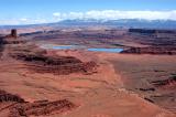
Looking east. Most of the evaporation ponds are visible here (some are out of view to the left).
The ridge at the right end of the ponds is part of Pyramid Butte. The dirt road is Shafer Trail.
If you look at the ORIGINAL size image, you can just barely see the access road leading
into the frontmost pond on the right---it looks like a sliver of dirt. Here's what
the road looks like up close: http://www.pbase.com/listorama/image/71555669 .
.
All images are copyright 1966 - 2023 by Dave Beedon (davebeedon AT comcast DOT net).