


|
|
|
|
|
|
| |
| 17-Sep-2019 | AKMC |
The funivia that we see today was not the original. The story dates back to 1900, and the birth of Secondino ("Dino") Lora Totino, son of a Piemontese family from the city of Pray. The family worked in the wool textile industry, but Dino decided to study engineering. He combined his family's field with his studies to develop threads of steel to produce cables for cable cars. His first one was designed in 1932 and runs from Breuil-Cervinia to Plateau Rosà on Cervino. Where? You probably know Cervino better as the Matterhorn. According to a note on a wall in Hangar 2173 (where we are at the moment; it's the museum for the funivia) that one is still in use today, though it's pretty clear that there have been significant upgrades to it over the years.
The feat was impressive enough to earn the title of "Count" (Conte) for Lora Totino. (Remember that Italy was still a monarchy back then. It would be the equivalent of a knighthood in some British Commonwealth countries.)
Building on from that, Conte Lora Totino obtained the rights to build a cable car at Courmayeur in 1940, with the first leg running from the floor of the valley to where we are here being completed in a year. (Fun fact; apparently that cable ran from La Palud, a village a few hundred metres east of the base station that we saw earlier. Google Maps, with its head still stuck in the 1940s, STILL shows the Skyway as departing from that point despite it having moved west to the new base station. That's why there's a significant disconnect between the two on Google Maps. You can see this in image 190917_000003_M003 earlier in this gallery.)
Of course, a certain event that Mussolini got Italy embroiled in halted work for half a decade. After the war, in 1947, the funivia was extended up to its current destination of Punta Helbronner.
That still wasn't enough for him, however. He built a cable car in France from Chamonix (a ski resort town in France) to Aiguille de Midi which is a 3842 m high summit in the Mont Blanc massif. "Aiguille" is a French word meaning "needle"; a number of nearby mountains have it as part of their name. That mountain sits about 5 km to the north-west of Punta Helbronner. This was part of a plan to unite the French side and the Italian side of the mountain range via cable cars. And, indeed, he managed to do that in 1958. We will see some of these cable cars that run between Aiguille de Midi and of Punta Helbronner later in this gallery. You can get some idea of their location from the 190917_000004_M004 map in this gallery.
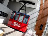
Here, we see one of the cars from the 1947 instance of the funivia. (FuniviE is the plural. I've used the singular in most cases to refer to the entire system, even though obviously it will have multiple individual cars.)
©2000-2024 AKMC. May not be used, copied or reproduced or used in AI training without written permission, especially by Facebook