I thought this morning might be a good one for a sunrise, so I set my clock for early and made it up to the Blue Ridge Parkway in plenty of time. Problem was that low clouds moved in and I couldn't see beyond my headlights. There was still a half hour until sunrise and good things come to those that wait - or something like that. Not me tho, I bailed out and headed towards the Smokies. Next on the list was the Alum Cave Trail up to Peregrine Peak and the Bluffs. I had wanted to do Ramsay Cascades, but the weather report wasn't good for photography and I didn't want to haul my stuff 4 miles uphill and end up with crappy photos. So I was checking my Smokies map for a trail and spotted the Alum Cave Trail. All that I knew about it was that it went up to Mt LeConte Lodge, so it was probably a lot of uphill. When I did a quick search, I found out there were a couple of interesting features along the trail. I didn't intend to hike all the way up to the lodge today, just to Peregrine Peak.
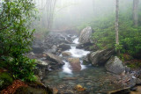
As I got a little lower in elevation on the Parkway, the fog thinned out. The trail is in Tennessee, so I turned north on Hwy 441. 3 elk were grazing in the grassy areas just past the visitor's center, so I pulled over. It was now raining lightly and was still kind of darkish, so I didn't shoot any stills. I had the video head on the tripod, so I set it up in the passenger's seat, rolled the window down and shot a few minutes worth of them eating grass, then one licked another one's face, then one kicked at another because it was invading his personal space - exciting stuff. So then I moved on, but as I got higher in elevation, the fog thickened. The Alum Cave Trailhead is past Clingman's Dome and maybe 2-3 miles farther down 441 on the right. It's a big parking area, but it fills up and overflows so go early if you plan to do it. The trail begins by crossing Walker Camp Prong, then it follows this creek up for over a mile. It was so foggy I didn't shoot many from the trail, but it's a really scenic hike with some nice trees to begin with. Above is a foggy creek shot.