


|
|
|
|
|
|
| |
| 07-APR-2015 | Robert Von Mayr |
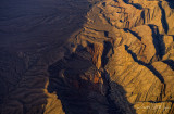
Basin and range faulting is displayed here, with the land on the right side having sheared off along a fault line, stretched, and broken as the land tilted. So the layers of the earth are at approximately 60 degrees from horizontal here.
Copyright 2003-2017 - All rights reserved. No usage without explicit written permission
| comment | |