


|
|
|
|
|
|
| |
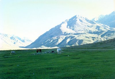
| July 27, 1989 | Noor Mohammad Khan |
Our Pakistani Military map said this place was called Burbolango Shal. Our altimeter said the altitude was 11,000 ft. It was only a few hours ride off the Shandur but the sunshine convinced us to camp here. After 3 days of mostly rain and mist on the Shandur Top we took advantage of the sun and the stream (Ghizer River) to wash the horses, and ourselves. The water was icy, right off the mountain snows, but the sun thawed us out afterwards. This photo was taken in the morning as the sun was just falling on the mountains to the west.
Copyright © Noor Mohammad Khan.