


|
|
|
|
|
|
| |
| 30-APR-2009 | |
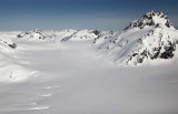
Mt John Jay/Border Peak 18 (N 56°08' 29" W 130°25' 31") is at L background.
The lower peaks at center appear to be unnamed.
Mt Upshur is out of view at L. Its NW shoulder is just visible at L.
Note snowmobile tracks, center.
Ref. map 104B-01
Copyright 2002-2023, John H. Scurlock, Photographer/Pilot