


|
|
|
|
|
|
| |
| 22-OCT-2006 | Dave Beedon |
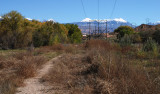
Looking southeast toward the La Sal Mountains. Moab is straight ahead about two miles. Kane Creek
Boulevard is off to the right. Most of the wetlands walking takes place in the trees at upper left.
This picture was taken at the center of this WikiMapia aerial view (click on any rectangle for information):
http://www.wikimapia.org/#y=38574562&x=-109575201&z=18&l=0&m=a&v=2 . Since the aerial
photo was taken the brush (small trees) was cut, opeing up the area considerably.
.
All images are copyright 1966 - 2023 by Dave Beedon (davebeedon AT comcast DOT net).
| Gary Winters | 24-Jun-2007 16:48 | |