


|
|
|
|
|
|
| |
| 09-JUN-2007 | Dave Beedon |
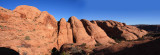
I took this picture (made of two-hand-held images) while ascending from garden #4 (site of the "flora
experiment") to the plateau containing the Poison Spider Mesa Trail. My position was at the center of
this WikiMapia aerial view: http://www.wikimapia.org/#y=38543911&x=-109615552&z=17&l=0&m=a&v=2 .
The sky is a mess because of my inexperience with filling in with colors.
.
All images are copyright 1966 - 2023 by Dave Beedon (davebeedon AT comcast DOT net).
| Rick Decker | 04-Nov-2007 23:40 | |