


|
|
|
|
|
|
| |
| 19-OCT-2006 | Dave Beedon |
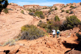
This is the lower end of the section of trail that follows a gently-ascending drainage.
It lies between the huge, open rock slab and the pathway blasted into the side of a hill.
The hikers are at the center of this WikiMapia aerial view (click any rectangle for
information): http://www.wikimapia.org/#y=38741909&x=-109505314&z=17&l=0&m=a&v=2 .
.
All images are copyright 1966 - 2023 by Dave Beedon (davebeedon AT comcast DOT net).
| 1moremile | 04-Jun-2007 23:30 | |
| Dave Beedon | 03-Jun-2007 00:41 | |
| 1moremile | 03-Jun-2007 00:39 | |
| 1moremile | 01-Jun-2007 00:04 | |
| Guest | 01-Jun-2007 00:00 | |