photo sharing and upload picture albums photo forums search pictures popular photos photography help login
Dave Beedon | all galleries >> Places >> Utah >> Moab (environs) >> Shafer Trail >> Shafer Trail: Second Visit > Looking back at my route
previous | next
12-APR-2006 Dave Beedon

Looking back at my route

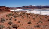
Shafer Trail follows the left (west) edge of the white ponds. I came from the upper left part of this scene. The ponds appear in this WikiMapia aerial photo:

http://www.wikimapia.org/#y=38481881&x=-109683466&z=14&l=0&m=a&v=2 .

.

Nikon D100 ,Nikkor 20mm f/2.8 AF
1/320s f/13.0 at 20.0mm full exif

other sizes: small medium large original auto
share
Type your message and click Add Comment
It is best to login or register first but you may post as a guest.
Enter an optional name and contact email address. Name
Name Email
help private comment