


|
|
|
|
|
|
| |
| 10 Jul 2004 | Dave Beedon |
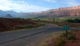
Looking southeast down the valley from the turn-off to the "town" of Castle Valley. This is just
west of the south end of Parriott Mesa. Porcupine Rim on the right runs down the valley toward
the La Sal Mountains. The low, dark hill at far left is Round Mountain (see next photo).
Topographic map: USGS Big Bend, UT (1:24,000).
| Full EXIF Info | |
| Date/Time | 10-Jul-2004 07:38:07 |
| Make | Nikon |
| Model | D100 |
| Flash Used | No |
| Focal Length | 28 mm |
| Exposure Time | 1/160 sec |
| Aperture | f/10 |
| ISO Equivalent | |
| Exposure Bias | |
| White Balance | (9) |
| Metering Mode | matrix (5) |
| JPEG Quality | (6) |
| Exposure Program | manual (1) |
| Focus Distance | |
All images are copyright 1966 - 2023 by Dave Beedon (davebeedon AT comcast DOT net).
| The Sigma Users Group Galleries | 27-Dec-2010 17:31 | |
| fotabug | 09-Dec-2005 13:22 | |