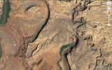
"Jackson-Kane plateau" is the fomation at center. It tilts downhill to the northeast. Its high point is the southwest end.
The curving shadow on its left side is the boundary between the plateau and Jackson Hole, an abandoned meander of the Colorado river (visibleat far left). The winding Kane Springs Canyon forms the boundary on the right side of the plateau.
The plateau's northern end is at the bottom of the tilt and is home to two mountain-biking trails---HyMasa Trail and Captain Ahab Trail---and a formation known as "The Whale." Access to the plateau is via the Amasa Back Trail, the aforementioned mountain-biking trails, and a 4x4 road that runs up the diagonal canyon of the plateau to its dead end.
Where the canyon ends in cliffs and a pour-off, mostly-easy scrambling gives the hiker access to the upper plateau and the high point at the southwest end.
Views of the surrounding terrain are had from the aforementioned trails, but end when one enters the bottom of the canyon. They are had again (but here are breath-taking) only when reaching the area at the top end of the plateau. It's a fascinating landscape.
|