photo sharing and upload picture albums photo forums search pictures popular photos photography help login
Dave Beedon | all galleries >> Photography >> Aerial Imagery > Upheaval Dome... 20141230
previous | next
David E. Beedon

Upheaval Dome... 20141230


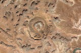
This is meant to be a Google Earth duplicate of a NASA photo taken from the International Space Station, which appears in the Flickr account of NASA's Marshall Space Flight Center. This image is rotated to match that from NASA. North is at bottom left. The top of the image is southeast. I created it to see how similar the two images were. The Google Earth imagery has morning shadows and the NASA's ISS image has afternoon shadows.

Upheaval Dome is in Canyonlands National Park, 23 miles (37 km) west-southwest of Moab, Utah. It's at the center of this Wikimapia aerial view.


other sizes: small medium large original auto
share
Type your message and click Add Comment
It is best to login or register first but you may post as a guest.
Enter an optional name and contact email address. Name
Name Email
help private comment