Dave Beedon
|
all galleries
>>
Places
>>
Utah
>>
Moab (environs)
>>
Tombstone Plateau
> Namesake of the Tombstone plateau
previous
|
next
12-MAY-2014
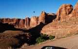
Namesake of the Tombstone plateau
view map
The Tombstone is the fin under the black dot. This was shot from Kane Creek Road, near the turn-off for the Amasa Back Trail.
Nikon D80
1/320s f/10.0 at 24.0mm iso200
full exif
other sizes:
small
medium
large
original
auto
previous
|
next
All images are copyright 1966 - 2023 by Dave Beedon (davebeedon AT comcast DOT net).
share
Type your message and click Add Comment
It is best to
login
or
register
first but you may post as a guest.
Enter an optional name and contact email address.
Name
Name
Email
help
private comment
Type your message and click Add Comment
It is best to
login
or
register
first but you may post as a guest.
Enter an optional name and contact email address.
Name
Name
Email
help
private comment