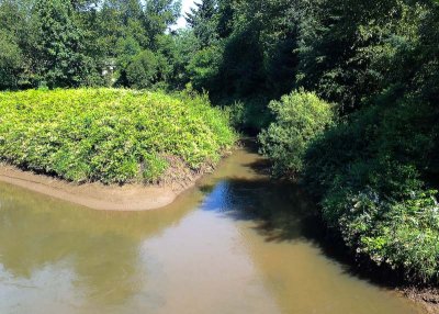
Springbrook Creek, at top, flows into the Green River in Tukwila, Washington (south of Seattle). The river is flowing from lower right to upper left on its way to Elliott Bay in Seattle. This confluence is the place where the Green River changes into the Duwamish River. I think that name change dates to the time when the Black River flowed here (up until 1916).
Springbrook Creek is a remnant of the former Black River, which flowed into the Green River here. The Black River, flowing through Renton, used to be the outlet for Lake Washington. When the Lake Washington Ship Canal was constructed, joining Lake Washington with Lake Union and Puget Sound, Lake Washington was lowered to the level of Lake Union, a change of nine feet. That left the lake's former outlet---the Black River---high and dry. Eventually much of the Black River's channel in Renton was filled in.
Springbrook Creek drains the Kent Valley and flows through the lowest portion of the former Black River on its way to this confluence. The railroad junction in this area is "Black River Junction.".
iPhone photo during a trike ride on the Green River Trail.. My vantage point was the pedestrian/cyclist bridge at the north end of Fort Dent Park, location of the Starfire Sports Center.
|