


|
|
|
|
|
|
| |
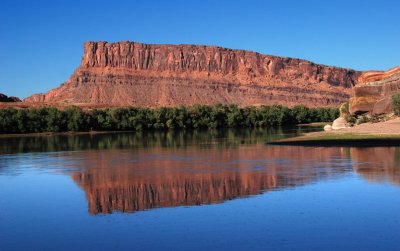
Looking northeast from the water's edge at the Potash boat ramp. The river is flowing toward
this vantage point, away from Moab. The prominent cliff is part of the south wall of Amasa
Back. The USGS topographic map labels this spot as "JL Eddy." Picture was taken at 5 p.m.
.
All images are copyright 1966 - 2023 by Dave Beedon (davebeedon AT comcast DOT net).
| John Cooper | 10-Apr-2014 19:44 | |
| Jason Anderson | 15-Mar-2009 00:19 | |
| Guest | 07-Mar-2009 08:51 | |
| Monte Dodge | 05-Mar-2009 04:33 | |
| exzim | 05-Mar-2009 01:51 | |