photo sharing and upload picture albums photo forums search pictures popular photos photography help login
RALPH ELDRIDGE | all galleries >> Galleries >> MACHIAS SEAL ISLAND { MSI } > 004 MSI GRID MAP
previous | next

004 MSI GRID MAP

MACHIAS SEAL ISLAND, NEW BRUNSWICK, CANADA

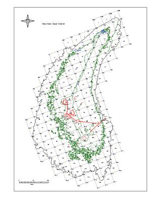
THE MAP GRID SQUARES ARE 30M X 30M. THE LARGER PERIMETER OUTLINE SHOWS THE AREA WHICH IS ABOUT NORMAL TIDE {AND MOST STORM SEA} LEVELS. THE INNER PERIMETER {GREEN} SHOWS THE AREA WHICH IS HIGH ENOUGH ABOVE WATER TO SUPPORT VEGETATION. MAXIMUM DIMENSION {VEGETATED} IS 150 METRES X 270 METRES
THE RED ARE EXISTING HUMAN STRUCTURES, MAINLY HOUSES, LIGHTTOWER AND CONNECTING BOARDWALKS.

SCANNED COPY OF ACWERN WORK MAP full exif

other sizes: small medium large auto
share
Type your message and click Add Comment
It is best to login or register first but you may post as a guest.
Enter an optional name and contact email address. Name
Name Email
help private comment