


|
|
|
|
|
|
| |
| 21-FEB-2012 | Jola Dziubinska |
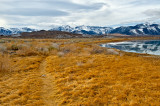
Seen from Navy Beach. Sierra Nevada Mountains and Panum crater in the background.
The Mono Basin is an endorheic drainage basin located east of Yosemite National Park in California and Nevada. It is bordered to the west by the Sierra Nevada, to the east by the Cowtrack Mountains, to the north by the Bodie Hills, and to the south by the north ridge of the Long Valley Caldera. Estimates of the size of the basin range from 634 to 801 square miles, and the basin's elevation ranges from around 6,380 feet (level of Mono Lake as of 1986) to 13,061 feet atop Mount Dana near the Sierra Crest.
Geologically the basin is a structural basin that is bordered to the west by the frontal fault of the Sierra Nevada. The basin has developed over the past three million years.
Notable features in the basin include Mono Lake and the Mono-Inyo Craters, as well as the town of Lee Vining.
Panum Crater is the dark volcanic cone in the middle of photo, that is part of the Mono-Inyo Craters, a chain of recent volcanic cones south of Mono Lake.
These images may not be used in any form without permission. Copyright © 2004-2023 Jola Dziubinska. All Rights Reserved.
Please login or register.