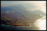
Aerial view facing south of Palos Verde Peninsula from AA flight 424.
The very bright areas to the right are from sunshine on the water with some window glare.
Palos Verde Point/Rocky Point is in the foreground to the right of center; Point Vincente is the point at the extreme western (seaward) edge of the Peninsula with Los Angeles Harbor visible, but very hazy, at the top left of the image.
The following photos show a few topographical features as seen from a sailboat rounding the PV peninsula about 1/4 mile offshore from a bit east of PV point to Point Vincente.
For an incredible set of photos of the entire California coasline see: http://www.californiacoastline.org/