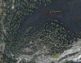
A google earth view of the waypoints I set on the route.
(click on the small photo for a better view)
0. Leave John Muir Trail
37�43'46.56"N
119�33'28.14"W
1. Old Trail
37�43'46.38"N
119�33'25.08"W
2. Trail continues
37�43'45.66"N
119�33'23.46"W
3. Rockslide 1
37�43'44.52"N
119�33'21.30"W
4. Trail continues
37�43'44.28"N
119�33'20.52"W
5. Rockslide 2
37�43'43.86"N
119�33'20.28"W
6. Trail
37�43'40.92"N
119�33'21.12"W
7. Trail
37�43'39.00"N
119�33'20.28"W
8. Sierra Point lookout
37�43'37.32"N
119�33'20.16"W