


|
|
|
|
|
|
| |
| 05-MAR-2007 | |
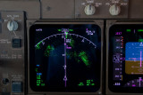
The white diamond represents another aircraft coming the opposit direction. He's +1900 feet above us.
The terrain mode is selected on this display, indicated by TERR. The numbers below TERR indicate the highest and lowest terrain being displayed (the green splotches). In this case we have terrain between 6,600 feet and 12,600 feet being displayed. The high density green represents the 12,600 feet peaks, the low density green represents the terrain at 6,600 feet.
The aircraft is 125 nautical miles past position Fukang (FKG). SARIN is on the border of China and Kazakhstan. And position "O" represents waypoint "Tacheng", a Chinese NDB. Obvious choice of ident, isn't it?
All Images Copyright, Rod Andrewartha, 2004-2019