


|
|
|
|
|
|
| |
| 14-OCT-2006 | Dave Beedon |
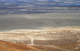
On the east side of Floating Island a faint dirt route branches off of the gravel road
toward the mud flats. It then becomes a confusion of tire tracks on the playa. The tracks
converge at Gate 74 (top of the grayish area). The variety of routes to the gate might
reflect the varying driving conditions due to the moisture level of the playa.
The white specks forming a straight line are warning signs posted on the boundary fence.
The pattern of tire tracks appears in this WikiMapia aerial photo:
http://www.wikimapia.org/#y=40913561&x=-113616486&z=16&l=0&m=a&v=2 .
A close-up view of the tire tracks: http://www.pbase.com/listorama/image/48608967 .
A close-up view of the gate: http://www.pbase.com/listorama/image/48608971 .
.
.
All images are copyright 1966 - 2023 by Dave Beedon (davebeedon AT comcast DOT net).
| Dave Beedon | 26-May-2007 21:23 | |
| Jason Anderson | 25-May-2007 21:53 | |
| 1moremile | 29-Dec-2006 01:16 | |