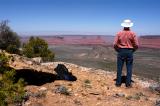
I like to experience landscape features up close (usually on foot) and from a distance.
The former allows an intimate relation with the terrain. The latter enables me to
appreciate the terrain’s physical context. Here I'm getting the "context" view of three
features I have explored on foot: Round Mountain, Castleton Tower, and Sister Superior.
Left of my waist is Round Mountain, sitting in Castle Valley. Above it,
atop a cone-shaped base, is Castleton Tower. The tower is visually blended with the
tower feature (the Rectory) behind it, making it seem wider than it is. Behind and
left of that, on the same ridge, is Sister Superior , which I got close to in 2004. Other
features are: The Convent (the butte beyond Sister Superior); Parriott Mesa (the
shadowy butte above my backpack), and Adobe Mesa (next to my right shoulder).
This shot looks northwest from Porcupine Rim, southeast of Moab, where Sand Flats Road
crosses into the Manti-La Sal National Forest. While I was here several mountain bikers
passed by on the nearby Porcupine Rim Trail. (This section of the trail is unmarked on
the “Latitude 40 Degree” maps.)
Once again I have to thank my personal assistant, Joe Tripod, for helping me take a picture.
.