


|
|
|
|
|
|
| |
| 12-APR-2006 | Dave Beedon |
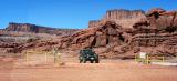
The private road is in the foreground. Shafer Trail crosses it, then
turns right behind the low boulders to the right of the Jeep.
This shot was taken at the center of this WikiMapia aerial view (click on any
rectangle): http://www.wikimapia.org/#y=38490564&x=-109672737&z=16&l=0&m=a&v=2 .
Six months after this shot I approached this intersection from the left on the
private mine road and had this view: http://www.pbase.com/image/82416620 .
.
All images are copyright 1966 - 2023 by Dave Beedon (davebeedon AT comcast DOT net).