


|
|
|
|
|
|
| |
| 12-APR-2006 | Dave Beedon |
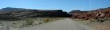
This is just south of the end of Potash Road, which ends at the grade
crossing ( http://www.pbase.com/listorama/image/52242937 ) of the
mining facility. The road here is officially designated Federal
Route 1694, described at http://www.pbase.com/listorama/2006ut2_road .
The red rocks at right form a man-made plateau that supports a long railroad track for storing
freight cars. About a mile ahead, around two curves, is the boat launch at J. L. Eddy.
.
All images are copyright 1966 - 2023 by Dave Beedon (davebeedon AT comcast DOT net).