


|
|
|
|
|
|
| |
| 23-DEC-2005 | |
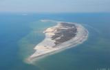
Ship Island is located appoximately twelve miles south of the coast. Hurricane Camille, in '69, severed the Island in half. On this flight I noticed that the cut looks to be about twice as wide as it was before Hurricane Katrina. Ship Island has an interesting history. For further info., click here.
images © J. Steven Martin - for usage or purchase info., click here.
| comment | |