When the Franks talk about their mountain, they popularly talk about the "Walberla", the striking table mountain east of Forchheim. The correct name of the mountain massif is “Ehrenbürg”. One of the largest Celtic settlements in the region is said to have once stood up here. 2,500 years ago, the entire plateau of this stately mountain was surrounded by a mighty stone wall. A reconstruction of this defensive wall can still be admired and the former wall can even be walked along a narrow and exciting path. The north peak is the 513.9 m high Walberla, the south peak is the 531.9 m high Rödenstein.
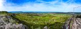
This is a pano of the north peak Walberla. On the left you see the 531.9 m high Rödenstein peak, in the far distance -center- view to Bamberg with the Cathedral. In the middle of the image there are cherry trees blossoming in Spring! Around Walberla is one of the largest contiguous fruit-growing area in Europe located.
*** Must be viewed at original size ***