The Piano Guys were coming to the Sydney Opera House. Tickets were obtained. The concert would not be for another 40 years... or so it felt at the time. When the time of the concert rolled around about 4 weeks after that (or so it felt at the time), there was no flapping way I wanted to be driving 2 hours or so to get home in the single hours of the following morning. A hotel was therefore booked near the Opera House. This afforded an opportunity to wander around with the camera that afternoon, the evening before the show, and the following morning.
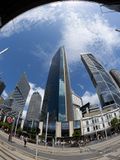
This is Alfred Street, Circular Quay. At one time it was a transport hub with buses connecting to the elevated Circular Quay railway station behind me, and the ferries at the wharves beyond that. (Above the railway line is a deck holding the Cahill Expressway; part of that is visible at the top of the frame.) Alfred St runs parallel to the rail lines which run parallel to the waterfront and its wharves. These days the street is closed to most traffic though newly installed trams still make their way here. In the foreground you can see the main tram ("L" for Light Rail) stop.
Having a view directly over Circular Quay, this is prime real estate and saw some of the earliest skyscrapers appear. The 115 metres (377 feet) AMP Building, created by a then-powerful financial company to act as its headquarters, was one of the first such status symbols in 1962. You can just see the edge of it surrounded by scaffolding (it's being renovated) on the far left of the frame.
In the late 60's it was one of only two (relatively) tall buildings on Alfred Street. The other was built in 1966; the 27 storey, 110 metre Goldfields House which was built by the former British gold mining company Consolidated Gold Fields. That was demolished in 2018, and would have been barely visible on the right of the frame even had it not been. The site has had a chequered history since then, including a fire. At the moment it's still essentially a hole in the ground but someday Australia's first Waldorf Astoria hotel, and a skyscraping residential tower, will rise there. Maybe.
The building in the centre is the Gateway, a commercial building which is older than I thought it was, having been built in 1989. It's 164 metres with 46 floors. Officially its address is 1 Macquarie Place, but that's a piddly little laneway running down the left side of it. You can't see it from this angle but when I took this shot the name on top of the building was "Credit Suisse", a bank which occupied the 31st floor. And which imploded spectacularly a mere 11 days after this shot was taken, so don't expect that name to stick around forever.
To its immediate left is Governor Phillip Tower, part of the 1 Farrer Place group of buildings, the second block to the south of Alfred St. It sits on the site of the original Government House, from which the eponymous Governor Arthur Phillip ruled the then-colony from the earliest years of European settlement. Many artefacts of that time are incorporated into its base. At 61 floors and 227 metres, it can look from some angles like the tallest building in Sydney, but that's an illusion. (It's the 11th tallest.) The bladed roof design has earned it the sobriquet "the milk crate".
The funky building to the left of that is the former AMP Centre (not to be confused with the previously mentioned AMP Building), which is now known as the Quay Quarter Tower. It briefly took the title of tallest in Sydney when it was built in 1976 but that was eclipsed by the MLC Centre (further south, out of shot) a year later. "They were building edifices like this in 1976?", I hear you exclaim. No, the original building was 188 metres, but it was remodelled in this funky style in 2018 and extended to 216 metres and 54 floors. It sits in Bridge Street, the one running to the south of and parallel to Alfred St.
In the gap to the right we can see the Marriott Hotel which will probably lose its harbour views if and when the Goldfields House redevelopment ever gets its guano together.
Next to the right is the Salesforce Tower, the second tallest building and tallest commercial building in Sydney. Its 53 floor, 263 metre bulk was completed in 2022. Technically its address is 180 George Street, the street that runs perpendicular to Alfred on the right of frame.
The EY Centre from 2015, home to many blue suited accountants who may well be wondering if this is REALLY what they planned to do with their lives, peeks into the far right of the frame. It's next door at 200 George Street. It has 40 floors and stands a mere 155 metres high, making it equal 42nd highest in Sydney. The perspective is slightly odd since George Street obviously runs from front of frame to back, so you'd expect those two to be lined up in that direction yet... here they aren't. I believe that Salesforce Tower is set back from George Street a bit so that the EY Centre doesn't end up with a view of nothing but office windows.
So there we have it. Alfred Street today looks nothing like it did in 1970 when there were only two tall buildings forming a gateway, which in turn looked nothing like it did in 1920. And in 2070 it will probably look very different again. But for now, you have been given a guided tour of the street's cityscape encapsulated in a single shot. Thank you, fisheye lenses, for that one.