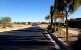
The road dips down to the level of a wide drainage swale, an area that collects and transports water during infrequent rain storms. Such swales are an integral part of housing and commercial developments in Maricopa, Arizona, the location of the pictured housing area. Some people might call these features washes.
I would estimate that the bottom of the dip is about eight feet (2.5 m) lower than the normal road level. This kind of water management seems to be a substitute for storm sewers. In some places it is cheaper and less trouble to lower a road to allow floodwater to pass over it than it is to build a bridge or construct a berm with culverts.
The first time I saw such a road dip was when I visited Arches National Park at Moab, Utah. There is a dip on the road to Delicate Arch Viewpoint, situated not far beyond the parking lot for Delicate Arch. The dip allows Winter Camp Wash, usually a dry stream, to flow over the road. When it does, it deposits piles of sand on the road, which must then be scooped up or pushed aside.
These road dips and swales are items of curiosity for a person like me whose home is in Western Washington State.
More info: en.wikipedia.org/wiki/Swale_%28landform%29 .
Photographed while i sat on my recumbent trike.
By the way, when I'm flooded, I never go anywhere.
|