photo sharing and upload picture albums photo forums search pictures popular photos photography help login
Dave Beedon | all galleries >> Places >> Utah >> Moab (environs) >> Other Moab Environs > Williams Bottom and Kane Springs Canyon
previous | next
15-MAY-2014 20140515_3172

Williams Bottom and Kane Springs Canyon

view map


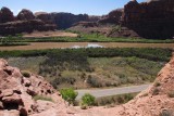
Looking southeast from a shelf on Poison Spider Mesa. At bottom is Potash Road (SR 279), passing through Williams Bottom. Across the Colorado River is the mouth of Kane Springs Canyon. The large dirt parking area is used by four-wheelers to unload their 4WD vehicles from trailers.

The original-size image has detail.

Nikon D80
1/500s f/13.0 at 18.0mm iso400 full exif

other sizes: small medium large original auto
share
Type your message and click Add Comment
It is best to login or register first but you may post as a guest.
Enter an optional name and contact email address. Name
Name Email
help private comment