photo sharing and upload picture albums photo forums search pictures popular photos photography help login
Dave Beedon | all galleries >> Places >> Utah >> Moab (environs) >> Negro Bill Canyon ("NBC") >> NBC Fins >> NBC Fins, Miscellaneous > Colorado River, seen from the highest fin on the plateau
previous | next
25-MAR-2007 20070325_8679

Colorado River, seen from the highest fin on the plateau


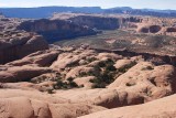
One of the goals of this hike was to scale the tallest fin on the plateau. On topographic maps it is identified by the elevation mark "4755T." The 360-degree view was delicious, partly because it exposed me to more terrain worthy of exploration. This view is to the west, showing a big S-curve of the Colorado River. The light-colored plateau on the far side of the river is the southernmost portion of Arches National Park.

Scaling the fin meant walking up the smooth, not-very-steep rock slope of the neighboring fin. The only difficulty was getting onto this fin where the two fins came together just below the top. A running start gave me the momentum to make the transition.

Nikon D80
1/320s f/7.1 at 28.0mm iso100 full exif

other sizes: small medium large original auto
share
Type your message and click Add Comment
It is best to login or register first but you may post as a guest.
Enter an optional name and contact email address. Name
Name Email
help private comment