


|
|
|
|
|
|
| |
| 17-SEP-2013 | Cindy Flood |
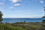
I thought you might enjoy the view from behind the “story-book” Point Iroquois lighthouse. The lighthouse is located on the shore of Lake Superior in Upper Michigan, near Brimley. Point Iroquois was named for Iroquois warriors massacred by the Ojibway Indians in 1662. White French explorers had come to the are in 1620.
You can see the 1000 foot Stuart J. Cort passing by, down bound through the Soo Locks. We had seen it 3 days earlier as we passed through the locks up bound.
In 1865, the St. Mary’s Falls Canal (now known as Soo Locks) was opened. The lighthouse was first lit in 1857 and the present house was built in 1870. The forth degree Fresnel lit one of the busiest shipping lanes in the world, as this is the entrance to the Saint Mary’s river and the Soo locks of Sault Sainte Marie. In 1975 the lighthouse was put on the National Historic. The lighthouse became history after 107 years in service and was replaced by an automatic light in the channel off of Gros Cap, Ontario.
DO NOT link, use, reproduce or alter this image or any part of this image. Copyright held by Cindy Flood.