


|
|
|
|
|
|
| |
| 20-SEP-2009 | Ian Dalgliesh |
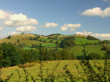
The farm in the centre of the image,isn't named on the largest scale OS Map,whilst the small grey roofed farm,on the left hillside is Ty - Mawr.The summits in view are
L to R:Pant-yr-alarch 308m.
Pen-y-Parc 343m.
Upper Trefnant 335m.